Saint-Pont
| Saint-Pont | |
|---|---|
|
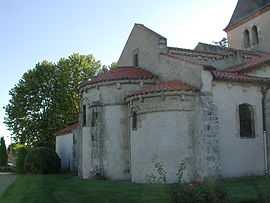
The church in Saint-Pont | |
 Saint-Pont | |
|
Location within Auvergne region  Saint-Pont | |
| Coordinates: 46°09′54″N 3°17′53″E / 46.165°N 3.2981°ECoordinates: 46°09′54″N 3°17′53″E / 46.165°N 3.2981°E | |
| Country | France |
| Region | Auvergne |
| Department | Allier |
| Arrondissement | Vichy |
| Canton | Escurolles |
| Intercommunality | Bassin de Gannat |
| Government | |
| • Mayor (2008–2014) | Pierre Prade |
| Area1 | 12.31 km2 (4.75 sq mi) |
| Population (2008)2 | 550 |
| • Density | 45/km2 (120/sq mi) |
| INSEE/Postal code | 03252 / 03110 |
| Elevation |
287–343 m (942–1,125 ft) (avg. 330 m or 1,080 ft) |
|
1 French Land Register data, which excludes lakes, ponds, glaciers > 1 km² (0.386 sq mi or 247 acres) and river estuaries. 2 Population without double counting: residents of multiple communes (e.g., students and military personnel) only counted once. | |
Saint-Pont is a commune in the Allier department in Auvergne in central France.
Population
| Historical population | ||
|---|---|---|
| Year | Pop. | ±% |
| 1962 | 365 | — |
| 1968 | 408 | +11.8% |
| 1975 | 387 | −5.1% |
| 1982 | 412 | +6.5% |
| 1990 | 435 | +5.6% |
| 1999 | 449 | +3.2% |
| 2008 | 550 | +22.5% |
See also
References
| Wikimedia Commons has media related to Saint-Pont. |