Saint-Paul-de-Fenouillet
| Saint-Paul-de-Fenouillet | ||
|---|---|---|
|
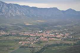
Saint-Paul-de-Fenouillet, seen from the trail of Saint-Martin | ||
| ||
 Saint-Paul-de-Fenouillet | ||
|
Location within Languedoc-Roussillon region  Saint-Paul-de-Fenouillet | ||
| Coordinates: 42°48′36″N 2°30′18″E / 42.81°N 2.505°ECoordinates: 42°48′36″N 2°30′18″E / 42.81°N 2.505°E | ||
| Country | France | |
| Region | Languedoc-Roussillon | |
| Department | Pyrénées-Orientales | |
| Arrondissement | Perpignan | |
| Canton | Saint-Paul-de-Fenouillet | |
| Intercommunality | Agly Fenouillèdes | |
| Government | ||
| • Mayor (2001–2008) | Bernard Foulquier | |
| Area1 | 43.90 km2 (16.95 sq mi) | |
| Population (2006)2 | 1,935 | |
| • Density | 44/km2 (110/sq mi) | |
| INSEE/Postal code | 66187 / 66220 | |
| Elevation |
170–966 m (558–3,169 ft) (avg. 267 m or 876 ft) | |
|
1 French Land Register data, which excludes lakes, ponds, glaciers > 1 km² (0.386 sq mi or 247 acres) and river estuaries. 2 Population without double counting: residents of multiple communes (e.g., students and military personnel) only counted once. | ||
.svg.png)
Saint-Paul-de-Fenouillet (Occitan: Sant Pau de Fenolhet) is a commune in the Pyrénées-Orientales department in southern France.
Twin towns
It is twinned with the town of Ennis in the Republic of Ireland.[1]
See also
References
| Wikimedia Commons has media related to Saint-Paul-de-Fenouillet. |