Saint-Loup, Allier
| Saint-Loup | ||
|---|---|---|
|
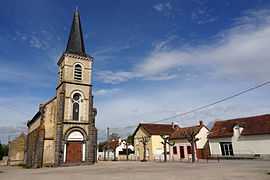
The church in Saint-Loup | ||
| ||
 Saint-Loup | ||
|
Location within Auvergne region  Saint-Loup | ||
| Coordinates: 46°21′07″N 3°22′43″E / 46.3519°N 3.3786°ECoordinates: 46°21′07″N 3°22′43″E / 46.3519°N 3.3786°E | ||
| Country | France | |
| Region | Auvergne | |
| Department | Allier | |
| Arrondissement | Vichy | |
| Canton | Varennes-sur-Allier | |
| Intercommunality | Pays Saint-Pourcinois | |
| Government | ||
| • Mayor (2008–2014) | Régis Claveau | |
| Area1 | 17.62 km2 (6.80 sq mi) | |
| Population (2008)2 | 595 | |
| • Density | 34/km2 (87/sq mi) | |
| INSEE/Postal code | 03242 / 03150 | |
| Elevation |
225–292 m (738–958 ft) (avg. 244 m or 801 ft) | |
|
1 French Land Register data, which excludes lakes, ponds, glaciers > 1 km² (0.386 sq mi or 247 acres) and river estuaries. 2 Population without double counting: residents of multiple communes (e.g., students and military personnel) only counted once. | ||

Saint-Loup is a commune in the Allier department in Auvergne in central France.
Population
| Historical population | ||
|---|---|---|
| Year | Pop. | ±% |
| 1962 | 567 | — |
| 1968 | 597 | +5.3% |
| 1975 | 578 | −3.2% |
| 1982 | 621 | +7.4% |
| 1990 | 619 | −0.3% |
| 1999 | 585 | −5.5% |
| 2008 | 595 | +1.7% |
See also
References
| Wikimedia Commons has media related to Saint-Loup, Allier. |