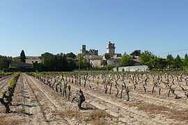
Saint-Laurent-des-Arbres
| Saint-Laurent-des-Arbres | ||
|---|---|---|
 | ||
| ||
 Saint-Laurent-des-Arbres | ||
|
Location within Languedoc-Roussillon region  Saint-Laurent-des-Arbres | ||
| Coordinates: 44°03′19″N 4°42′02″E / 44.0553°N 4.7006°ECoordinates: 44°03′19″N 4°42′02″E / 44.0553°N 4.7006°E | ||
| Country | France | |
| Region | Languedoc-Roussillon | |
| Department | Gard | |
| Arrondissement | Nîmes | |
| Canton | Roquemaure | |
| Intercommunality | Côte du Rhône Gardoise | |
| Government | ||
| • Mayor (2008–2014) | Michel Anastasy | |
| Area1 | 16.35 km2 (6.31 sq mi) | |
| Population (2008)2 | 2,289 | |
| • Density | 140/km2 (360/sq mi) | |
| INSEE/Postal code | 30278 / 30126 | |
| Elevation |
39–261 m (128–856 ft) (avg. 60 m or 200 ft) | |
|
1 French Land Register data, which excludes lakes, ponds, glaciers > 1 km² (0.386 sq mi or 247 acres) and river estuaries. 2 Population without double counting: residents of multiple communes (e.g., students and military personnel) only counted once. | ||

Saint-Laurent-des-Arbres is a commune in the Gard department in southern France.
Population
| Historical population | ||
|---|---|---|
| Year | Pop. | ±% |
| 1936 | 515 | — |
| 1946 | 521 | +1.2% |
| 1954 | 701 | +34.5% |
| 1962 | 900 | +28.4% |
| 1968 | 1,847 | +105.2% |
| 1975 | 2,056 | +11.3% |
| 1982 | 1,403 | −31.8% |
| 1990 | 1,683 | +20.0% |
| 1999 | 1,743 | +3.6% |
| 2009 | 2,400 | +37.7% |
References
Further reading
- Corvisier, Christian (2000). "Saint-Laurent-des-Arbres. Eglise fortifiée, château et tours". Congrès archéologique de France - Monuments du Gard, 157éme session 1999 (in French). Paris: Société française d'archéologie. pp. 311–337. OCLC 48728034.
External links
| Wikimedia Commons has media related to Saint-Laurent-des-Arbres. |