Saint-Lô
| Saint-Lô | ||
|---|---|---|
 | ||
| ||
 Saint-Lô | ||
|
Location within Lower Normandy region  Saint-Lô | ||
| Coordinates: 49°07′N 1°05′W / 49.12°N 1.09°WCoordinates: 49°07′N 1°05′W / 49.12°N 1.09°W | ||
| Country | France | |
| Region | Lower Normandy | |
| Department | Manche | |
| Arrondissement | Saint-Lô | |
| Intercommunality | Saint-Loise | |
| Government | ||
| • Mayor (2008–2014) | François Digard | |
| Area1 | 23.19 km2 (8.95 sq mi) | |
| Population (1999)2 | 20,090 | |
| • Density | 870/km2 (2,200/sq mi) | |
| INSEE/Postal code | 50502 / 50000 | |
| Elevation |
7–134 m (23–440 ft) (avg. 14 m or 46 ft) | |
|
1 French Land Register data, which excludes lakes, ponds, glaciers > 1 km² (0.386 sq mi or 247 acres) and river estuaries. 2 Population without double counting: residents of multiple communes (e.g., students and military personnel) only counted once. | ||

Saint-Lô (French pronunciation: [sɛ̃lo]) is a commune in north-western France, the capital of the Manche department in Normandy.
History
Originally called Briovère (meaning "Bridge on the Vire River" in Gaulish), the town is built on and around ramparts. The town started life as a Gallic fortified settlement while the name "Saint-Lô", known since the 8th century, originates from Saint Laud, bishop of Coutances in 525–565, who had a residence here. According to tradition the town received a new line of walls from Charlemagne in the early 9th century. It was sacked by the Vikings in 890 and later flourished under the bishop Geffroy de Montbray, who built here a bridge and some mills.
Saint-Lô was the third largest town in the Duchy of Normandy after Rouen and Caen, and became part of France in 1202. In the 13th century it was home to numerous craftsmen, and in 1234 a guild of tailors was established. In 1275 it received the right to mint coins from King Philip III of France, which it maintained until 1693.
During the Hundred Years War it was sacked by the English, and in 1347 it was struck by plague. In 1378 it returned to France, but was again under England from 1418 to 1449. Saint-Lô suffered notably during the Wars of Religion —in 1562 it was captured by the Huguenots and became a Protestant stronghold then in 1574 it was besieged and partly destroyed by royal troops under Marshal de Matignon. Two years later the seigneury of the bishops of Coutances over the town ceased forever. In the mid-17th century part of the walls were destroyed, and the town grew with a new borough known as Neufborg. After the revocation of the edict of Nantes (1685), most craftsmen abandoned Saint-Lô.
In 1795 it became capital of the Manche department. In 1858 it was reached by the Paris-Cherbourg railway.
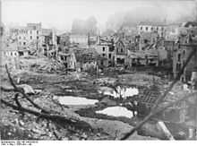
The German army occupied the town on 17 June 1940. As a strategic crossroads, Saint-Lô was almost totally destroyed (95% according to common estimates) during the Battle of Normandy in World War II, earning it the title of "The Capital of the Ruins" from Samuel Beckett. After the war the question arose as to whether the town should be rebuilt or left with its ruins intact as a testimony to the bombing. One American soldier laconically commented: "We sure liberated the hell out of this place".[1]
Heraldry
.svg.png) |
The arms of Saint-Lô are blazoned : Gules, a unicorn salient argent, on a chief azure, three fleurs de lys Or. |
St. Lo was one of the key cities to the opening of the Falaise Gap, which ultimately allowed Allied forces to expel German forces from northern France.
Main sights
Among the only standing buildings after the 1944 bombings was the Notre-Dame church, built in Flamboyant Gothic style from the 13th to the 15th centuries to replace the former castle's chapel; its roof and façade were destroyed, as well as one of its two towers and the top of the other one. The church was partially restored after the war: the façade was rebuilt as a plain green schist wall. It most notably features an outdoor pulpit that Victor Hugo protected from demolition planned for town renovation in 1863. The statue of Notre-Dame du Pilier is from 1467; having been destroyed and remade several times, it is now housed on a column in the apse chapel.
Saint-Lô also has remains of its medieval line of walls. They include: tour des Beaux Regards ("Tower of Beautiful Glances"), commanding the steepest part of the spur of the town, and the Tour de la Poudrière ("Tower of the Gunpowder Store"), the last relic of the old citadel.
The abbey church of Sainte-Croix ("Holy Cross") is, according to the tradition, the heir of a chapel built here by St. Helena in the 4th century and of an abbey founded by Charlemagne. More documented is the creation of an Augustinian abbey by the bishop of Coutances in 1132. The Romanesque church was consecrated in 1202, being largely remade in the following centuries. The choir was remade in the 16th century while the bell tower is from 1860–1863.
Saint-Lô is home to the largest of the 23 national stud farms in France.
As partial reparation for the destruction of the city, Americans established the hospital memorial, housing a [mosaic]] by Fernand Léger. It was at that time the largest hospital in Europe.
A memorial in the city honours Major Thomas Howie, Commander of the 3d Battalion, 116th Infantry Regiment of the U.S. Army's 29th Division; the unit that liberated the city on July 18, 1944. Howie was killed just before his unit entered the city and was so highly respected that his men placed his flag-draped body on the hood of a jeep at the front of the column so he could be the first American to enter the city. He became famous as the "Major of Saint-Lô".
Twin towns
.svg.png) Saint-Ghislain, Belgium, since 1961
Saint-Ghislain, Belgium, since 1961 Aalen, Germany, since 3 June 1979
 Christchurch, since 20 April 1985[2]
 Kervénanec, Lorient, France, since 11 September 1988
 Roanoke, USA, since 19 June 1999
See also
- Communes of the Manche department
- USS St. Lo (CVE-63), the United States Navy escort carrier named after the city following the landings at the city following Operation Overlord. She was sunk by kamikaze aircraft during the Battle of Leyte Gulf, being the first kamikaze casualty of the war.
References
- ↑ Reagan, Geoffrey. Military Anecdotes (1992) p. 33 Guiness Publishing ISBN 0-85112-519-0
- ↑ "British towns twinned with French towns [via WaybackMachine.com]". Archant Community Media Ltd. Archived from the original on 5 July 2013. Retrieved 2013-07-20.
External links
| Wikimedia Commons has media related to Saint-Lô. |
| Wikivoyage has a travel guide for Saint-Lô. |
- Town council website
- The bombing of Saint-Lo – June 1944
-
 "St Lô". Encyclopædia Britannica (11th ed.). 1911.
| ||||||