Saint-Julien-près-Bort
| Saint-Julien-près-Bort | ||
|---|---|---|
|
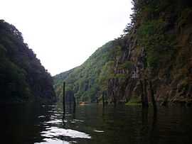
The Dordogne | ||
| ||
 Saint-Julien-près-Bort | ||
|
Location within Limousin region  Saint-Julien-près-Bort | ||
| Coordinates: 45°24′59″N 2°24′15″E / 45.4164°N 2.4042°ECoordinates: 45°24′59″N 2°24′15″E / 45.4164°N 2.4042°E | ||
| Country | France | |
| Region | Limousin | |
| Department | Corrèze | |
| Arrondissement | Ussel | |
| Canton | Bort-les-Orgues | |
| Intercommunality | Plateau Bortois | |
| Government | ||
| • Mayor (2008–2014) | Gilbert Fournial | |
| Area1 | 30.63 km2 (11.83 sq mi) | |
| Population (2008)2 | 422 | |
| • Density | 14/km2 (36/sq mi) | |
| INSEE/Postal code | 19218 / 19110 | |
| Elevation | 400–841 m (1,312–2,759 ft) | |
|
1 French Land Register data, which excludes lakes, ponds, glaciers > 1 km² (0.386 sq mi or 247 acres) and river estuaries. 2 Population without double counting: residents of multiple communes (e.g., students and military personnel) only counted once. | ||
.svg.png)
Saint-Julien-près-Bort is a commune in the Corrèze department in central France.
Geography
The river Diège forms all of the commune's western boundary, then flows into the Dordogne, which forms all of its southern boundary.
Population
| Historical population | ||
|---|---|---|
| Year | Pop. | ±% |
| 1962 | 543 | — |
| 1968 | 459 | −15.5% |
| 1975 | 367 | −20.0% |
| 1982 | 350 | −4.6% |
| 1990 | 373 | +6.6% |
| 1999 | 369 | −1.1% |
| 2008 | 422 | +14.4% |
See also
References
| Wikimedia Commons has media related to Saint-Julien-près-Bort. |