Saint-Jean-de-Cherbourg, Quebec
| Saint-Jean-de-Cherbourg | |
|---|---|
| Parish municipality | |
|
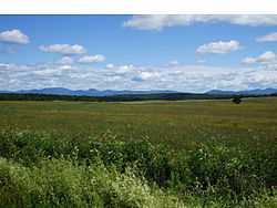
Landscape of St-Jean-de-Cherbourg. | |
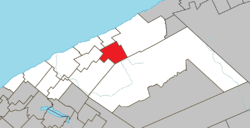 Location within La Matanie RCM. | |
 Saint-Jean-de-Cherbourg Location in eastern Quebec. | |
| Coordinates: 48°51′N 67°07′W / 48.850°N 67.117°WCoordinates: 48°51′N 67°07′W / 48.850°N 67.117°W[1] | |
| Country |
|
| Province |
|
| Region | Bas-Saint-Laurent |
| RCM | La Matanie |
| Settled | 1930 |
| Constituted | May 1, 1954 |
| Government[2] | |
| • Mayor | Jocelyn Bergeron |
| • Federal riding | Haute-Gaspésie—La Mitis—Matane—Matapédia |
| • Prov. riding | Matane-Matapédia |
| Area[2][3] | |
| • Total | 112.90 km2 (43.59 sq mi) |
| • Land | 114.05 km2 (44.03 sq mi) |
|
There is an apparent contradiction between two authoritative sources | |
| Population (2011)[3] | |
| • Total | 193 |
| • Density | 1.7/km2 (4/sq mi) |
| • Pop 2006-2011 |
|
| • Dwellings | 109 |
| Time zone | EST (UTC−5) |
| • Summer (DST) | EDT (UTC−4) |
| Postal code(s) | G0J 2R0 |
| Area code(s) | 418 and 581 |
| Highways | No major routes |
Saint-Jean-de-Cherbourg is a parish municipality in the Canadian province of Quebec, located in La Matanie Regional County Municipality.
Demographics
Population
| |||||||||||||||||||
Census data before 2001:[6]
- Population in 1996: 239 (+3.9% from 1991)
- Population in 1991: 230
See also
References
- ↑ Reference number 56875 of the Commission de toponymie du Québec (French)
- ↑ 2.0 2.1 "Saint-Jean-de-Cherbourg". Répertoire des municipalités (in French). Ministère des Affaires municipales, des Régions et de l'Occupation du territoire. Retrieved 2012-01-20.
- ↑ 3.0 3.1 3.2 "Saint-Jean-de-Cherbourg census profile". 2011 Census data. Statistics Canada. Retrieved 2012-01-20.
- ↑ "2006 Community Profiles". Canada 2006 Census. Statistics Canada. March 30, 2011. Retrieved 2012-01-20.
- ↑ "2001 Community Profiles". Canada 2001 Census. Statistics Canada. February 17, 2012. Retrieved 2012-01-20.
- ↑ Statistics Canada: 1996
| Wikimedia Commons has media related to Saint-Jean-de-Cherbourg. |
 |
Sainte-Félicité | Grosses-Roches | | |
| Saint-Adelme | |
Les Méchins | ||
| ||||
| | ||||
| Saint-René-de-Matane | Rivière-Bonjour |
| ||||||||||||||||||||||