Saint-Hilaire, Allier
| Saint-Hilaire | ||
|---|---|---|
|
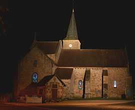
The church in Saint-Hilaire | ||
| ||
 Saint-Hilaire | ||
|
Location within Auvergne region  Saint-Hilaire | ||
| Coordinates: 46°29′43″N 3°01′15″E / 46.4953°N 3.0208°ECoordinates: 46°29′43″N 3°01′15″E / 46.4953°N 3.0208°E | ||
| Country | France | |
| Region | Auvergne | |
| Department | Allier | |
| Arrondissement | Moulins | |
| Canton | Bourbon-l'Archambault | |
| Intercommunality | Bocage Sud | |
| Government | ||
| • Mayor (2008–2014) | Olivier Guiot | |
| Area1 | 20.64 km2 (7.97 sq mi) | |
| Population (2008)2 | 524 | |
| • Density | 25/km2 (66/sq mi) | |
| INSEE/Postal code | 03238 / 03440 | |
| Elevation |
265–420 m (869–1,378 ft) (avg. 320 m or 1,050 ft) | |
|
1 French Land Register data, which excludes lakes, ponds, glaciers > 1 km² (0.386 sq mi or 247 acres) and river estuaries. 2 Population without double counting: residents of multiple communes (e.g., students and military personnel) only counted once. | ||

Saint-Hilaire is a commune in the Allier department in Auvergne in central France.
Population
| Historical population | ||
|---|---|---|
| Year | Pop. | ±% |
| 1962 | 796 | — |
| 1968 | 902 | +13.3% |
| 1975 | 700 | −22.4% |
| 1982 | 650 | −7.1% |
| 1990 | 595 | −8.5% |
| 1999 | 567 | −4.7% |
| 2008 | 524 | −7.6% |
See also
References
| Wikimedia Commons has media related to Saint-Hilaire (Allier). |