Saint-Faustin–Lac-Carré, Quebec
| Saint-Faustin–Lac-Carré | |
|---|---|
| Municipality | |
 | |
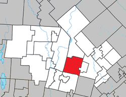 Location within Les Laurentides RCM. | |
 Saint-Faustin–Lac-Carré Location in central Quebec. | |
| Coordinates: 46°07′N 74°29′W / 46.117°N 74.483°WCoordinates: 46°07′N 74°29′W / 46.117°N 74.483°W[1] | |
| Country |
|
| Province |
|
| Region | Laurentides |
| RCM | Les Laurentides |
| Constituted | January 3, 1996 |
| Government[2] | |
| • Mayor | Pierre Poirier |
| • Federal riding | Laurentides—Labelle |
| • Prov. riding | Labelle |
| Area[2][3] | |
| • Total | 129.30 km2 (49.92 sq mi) |
| • Land | 121.28 km2 (46.83 sq mi) |
| Population (2011)[3] | |
| • Total | 3,467 |
| • Density | 28.6/km2 (74/sq mi) |
| • Pop 2006-2011 |
|
| • Dwellings | 2,407 |
| Time zone | EST (UTC−5) |
| • Summer (DST) | EDT (UTC−4) |
| Postal code(s) | J0T 1J2 |
| Area code(s) | 819 |
| Highways |
|
| Website |
www stfaustin |
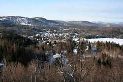
Saint-Faustin–Lac-Carré is a municipality in the Laurentides region of Quebec, Canada, part of the Les Laurentides Regional County Municipality.
Demographics
Population trend:[4]
- Population in 2011: 3467 (2006 to 2011 population change: 16.1%)
- Population in 2006: 2985
- Population in 2001: 2790
- Population in 1996: 2470
- Lac-Carré: 861
- Saint-Faustin: 1609
- Population in 1991:
- Lac-Carré: 801
- Saint-Faustin: 1410
Private dwellings occupied by usual residents: 1558 (total dwellings: 2407)
Mother tongue:
- English as first language: 4.5%
- French as first language: 90.9%
- English and French as first language: 0.8%
- Other as first language: 3.7%
References
- ↑ Reference number 312947 of the Commission de toponymie du Québec (French)
- ↑ 2.0 2.1 Geographic code 78047 in the official Répertoire des municipalités (French)
- ↑ 3.0 3.1 "(Code 2478047) Census Profile". 2011 census. Statistics Canada. 2012.
- ↑ Statistics Canada: 1996, 2001, 2006, 2011 census
 |
Lac-Supérieur | | ||
| Mont-Tremblant | |
Sainte-Agathe-des-Monts, Ivry-sur-le-Lac | ||
| ||||
| | ||||
| Arundel | Montcalm | Saint-Adolphe-d'Howard |
| ||||||||||||||||||||||||||