Saint-Ennemond
| Saint-Ennemond | ||
|---|---|---|
|
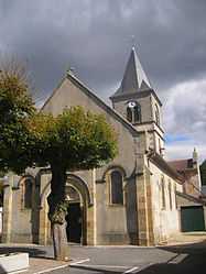
The church in Saint-Ennemond | ||
| ||
 Saint-Ennemond | ||
|
Location within Auvergne region  Saint-Ennemond | ||
| Coordinates: 46°40′37″N 3°25′24″E / 46.6769°N 3.4233°ECoordinates: 46°40′37″N 3°25′24″E / 46.6769°N 3.4233°E | ||
| Country | France | |
| Region | Auvergne | |
| Department | Allier | |
| Arrondissement | Moulins | |
| Canton | Yzeure | |
| Intercommunality | Moulins | |
| Government | ||
| • Mayor (2008–2014) | Jean-Claude Lefebvre | |
| Area1 | 38.08 km2 (14.70 sq mi) | |
| Population (2008)2 | 655 | |
| • Density | 17/km2 (45/sq mi) | |
| INSEE/Postal code | 03229 / 03400 | |
| Elevation |
209–258 m (686–846 ft) (avg. 220 m or 720 ft) | |
|
1 French Land Register data, which excludes lakes, ponds, glaciers > 1 km² (0.386 sq mi or 247 acres) and river estuaries. 2 Population without double counting: residents of multiple communes (e.g., students and military personnel) only counted once. | ||

Saint-Ennemond is a commune in the Allier department in Auvergne in central France.
Population
| Historical population | ||
|---|---|---|
| Year | Pop. | ±% |
| 1962 | 827 | — |
| 1968 | 827 | +0.0% |
| 1975 | 658 | −20.4% |
| 1982 | 671 | +2.0% |
| 1990 | 649 | −3.3% |
| 1999 | 617 | −4.9% |
| 2008 | 655 | +6.2% |
See also
References
| Wikimedia Commons has media related to Saint-Ennemond. |