Saint-Didier-la-Forêt
| Saint-Didier-la-Forêt | ||
|---|---|---|
|
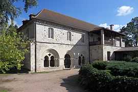
St. Gilbert Abbey | ||
| ||
 Saint-Didier-la-Forêt | ||
|
Location within Auvergne region  Saint-Didier-la-Forêt | ||
| Coordinates: 46°13′34″N 3°20′41″E / 46.2261°N 3.3447°ECoordinates: 46°13′34″N 3°20′41″E / 46.2261°N 3.3447°E | ||
| Country | France | |
| Region | Auvergne | |
| Department | Allier | |
| Arrondissement | Vichy | |
| Canton | Escurolles | |
| Intercommunality | Pays Saint-Pourcinois | |
| Government | ||
| • Mayor (2008–2014) | Claude Lavest | |
| Area1 | 33.59 km2 (12.97 sq mi) | |
| Population (2008)2 | 379 | |
| • Density | 11/km2 (29/sq mi) | |
| INSEE/Postal code | 03227 / 03110 | |
| Elevation |
246–323 m (807–1,060 ft) (avg. 280 m or 920 ft) | |
|
1 French Land Register data, which excludes lakes, ponds, glaciers > 1 km² (0.386 sq mi or 247 acres) and river estuaries. 2 Population without double counting: residents of multiple communes (e.g., students and military personnel) only counted once. | ||

Saint-Didier-la-Forêt is a commune in the Allier department in Auvergne in central France.
Population
| Historical population | ||
|---|---|---|
| Year | Pop. | ±% |
| 1962 | 456 | — |
| 1968 | 514 | +12.7% |
| 1975 | 427 | −16.9% |
| 1982 | 381 | −10.8% |
| 1990 | 375 | −1.6% |
| 1999 | 360 | −4.0% |
| 2008 | 379 | +5.3% |
See also
References
| Wikimedia Commons has media related to Saint-Didier-la-Forêt. |