Saint-Cyr-de-Valorges
| Saint-Cyr-de-Valorges | |
|---|---|
|
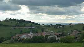
A general view of Saint-Cyr-de-Valorges | |
 Saint-Cyr-de-Valorges | |
|
Location within Rhône-Alpes region  Saint-Cyr-de-Valorges | |
| Coordinates: 45°53′32″N 4°18′25″E / 45.8922°N 4.3069°ECoordinates: 45°53′32″N 4°18′25″E / 45.8922°N 4.3069°E | |
| Country | France |
| Region | Rhône-Alpes |
| Department | Loire |
| Arrondissement | Roanne |
| Canton | Néronde |
| Intercommunality | Balbigny |
| Government | |
| • Mayor (2001–2008) | Gilles Chevron |
| Area1 | 9.91 km2 (3.83 sq mi) |
| Population (1999)2 | 274 |
| • Density | 28/km2 (72/sq mi) |
| INSEE/Postal code | 42213 / 42114 |
| Elevation |
526–892 m (1,726–2,927 ft) (avg. 640 m or 2,100 ft) |
|
1 French Land Register data, which excludes lakes, ponds, glaciers > 1 km² (0.386 sq mi or 247 acres) and river estuaries. 2 Population without double counting: residents of multiple communes (e.g., students and military personnel) only counted once. | |
Saint-Cyr-de-Valorges is a commune in the Loire department in central France.
See also
References
| Wikimedia Commons has media related to Saint-Cyr-de-Valorges. |