Saint-Cirgues-la-Loutre
| Saint-Cirgues-la-Loutre | ||
|---|---|---|
|
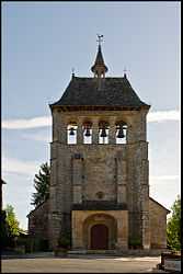
The church of Saint-Cyr-Sainte-Julitte | ||
| ||
 Saint-Cirgues-la-Loutre | ||
|
Location within Limousin region  Saint-Cirgues-la-Loutre | ||
| Coordinates: 45°04′46″N 2°05′58″E / 45.0794°N 2.0994°ECoordinates: 45°04′46″N 2°05′58″E / 45.0794°N 2.0994°E | ||
| Country | France | |
| Region | Limousin | |
| Department | Corrèze | |
| Arrondissement | Tulle | |
| Canton | Saint-Privat | |
| Government | ||
| • Mayor (2008–2014) | Auguste Molinier | |
| Area1 | 18.41 km2 (7.11 sq mi) | |
| Population (2008)2 | 196 | |
| • Density | 11/km2 (28/sq mi) | |
| INSEE/Postal code | 19193 / 19220 | |
| Elevation |
301–575 m (988–1,886 ft) (avg. 451 m or 1,480 ft) | |
|
1 French Land Register data, which excludes lakes, ponds, glaciers > 1 km² (0.386 sq mi or 247 acres) and river estuaries. 2 Population without double counting: residents of multiple communes (e.g., students and military personnel) only counted once. | ||
.svg.png)
Saint-Cirgues-la-Loutre is a commune in the Corrèze department in central France.
Geography
The Maronne river forms the commune's southeastern boundary.
Population
| Historical population | ||
|---|---|---|
| Year | Pop. | ±% |
| 1962 | 339 | — |
| 1968 | 362 | +6.8% |
| 1975 | 304 | −16.0% |
| 1982 | 267 | −12.2% |
| 1990 | 230 | −13.9% |
| 1999 | 188 | −18.3% |
| 2008 | 196 | +4.3% |
See also
References
| Wikimedia Commons has media related to Saint-Cirgues-la-Loutre. |