Saint-Bonnet-de-Four
| Saint-Bonnet-de-Four | |
|---|---|
|
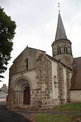
The church in Saint-Bonnet-de-Four | |
 Saint-Bonnet-de-Four | |
|
Location within Auvergne region  Saint-Bonnet-de-Four | |
| Coordinates: 46°18′49″N 2°54′40″E / 46.3136°N 2.9111°ECoordinates: 46°18′49″N 2°54′40″E / 46.3136°N 2.9111°E | |
| Country | France |
| Region | Auvergne |
| Department | Allier |
| Arrondissement | Montluçon |
| Canton | Montmarault |
| Intercommunality | Région de Montmarault |
| Government | |
| • Mayor (2008–2014) | Bernard Chapelier |
| Area1 | 18.73 km2 (7.23 sq mi) |
| Population (2008)2 | 200 |
| • Density | 11/km2 (28/sq mi) |
| INSEE/Postal code | 03219 / 03390 |
| Elevation |
318–476 m (1,043–1,562 ft) (avg. 467 m or 1,532 ft) |
|
1 French Land Register data, which excludes lakes, ponds, glaciers > 1 km² (0.386 sq mi or 247 acres) and river estuaries. 2 Population without double counting: residents of multiple communes (e.g., students and military personnel) only counted once. | |
Saint-Bonnet-de-Four is a commune in the Allier department in Auvergne in central France.
Population
| Historical population | ||
|---|---|---|
| Year | Pop. | ±% |
| 1962 | 269 | — |
| 1968 | 299 | +11.2% |
| 1975 | 259 | −13.4% |
| 1982 | 228 | −12.0% |
| 1990 | 227 | −0.4% |
| 1999 | 221 | −2.6% |
| 2008 | 200 | −9.5% |
Sights
- Church of Saint Bonnet, with its bent steeple and ornate doors.
The original church dates from the 11th century and is a designated historic monument. In the 14th century, a Gothic chapel was added on the right of the transept.
The steeple was struck by lightning in 1894 and rebuilt from green wood that subsequently warped and became a local curiosity. In 1978, when the church was restored, the requirement that it be rebuilt exactly like the original meant that the 1/8 turn in the steeple had to be maintained.
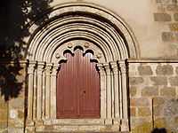
Door of the church
See also
References
| Wikimedia Commons has media related to Saint-Bonnet-de-Four. |