Sailauf
| Sailauf | ||
|---|---|---|
| ||
 Sailauf | ||
Location of Sailauf within Aschaffenburg district 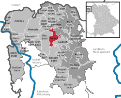 | ||
| Coordinates: 50°01′N 09°15′E / 50.017°N 9.250°ECoordinates: 50°01′N 09°15′E / 50.017°N 9.250°E | ||
| Country | Germany | |
| State | Bavaria | |
| Admin. region | Unterfranken | |
| District | Aschaffenburg | |
| Government | ||
| • Mayor | Gerhard Steigerwald (CSU) | |
| Area | ||
| • Total | 13.82 km2 (5.34 sq mi) | |
| Population (2013-12-31)[1] | ||
| • Total | 3,623 | |
| • Density | 260/km2 (680/sq mi) | |
| Time zone | CET/CEST (UTC+1/+2) | |
| Postal codes | 63877 | |
| Dialling codes | 06024 und 06093 | |
| Vehicle registration | AB | |
| Website | www.sailauf.de | |
Sailauf is a community in the Aschaffenburg district in the Regierungsbezirk of Lower Franconia (Unterfranken) in Bavaria, Germany.
Geography
Location
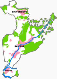
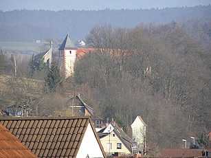
The community lies in the Vorspessart (range) near Aschaffenburg and is among the Vorspessart’s oldest settled centres. The outlying centre of Eichenberg belongs to the community.
History
As early as 1089, the original church in the upper Aschaff valley stood here.
In 1189, the lordly estate of Sigilovf(e), meaning “Glistening Brook”, and out of whose name arose the placename Sailauf, had its first documentary mention. In the 13th century, Sailauf was for a short time ruled by the Counts of Rieneck, who built the castle “Landesere” on the nearby Gräfenberg. In 1265, the Elector of Mainz, Werner von Eppstein built the hunting castle “castrum vivarium”, which was later named Weyberhof. While the Plague raged in Europe in 1349, the Vorspessart was all but empty of people. Newcomers later came to Sailauf from the Steigerwald. In 1552, Weyberhof Castle was destroyed.
In the Thirty Years' War (1618–1648), Sailauf was almost utterly destroyed. In 1789, Saint Vitus’s Church (Sankt-Vitus-Kirche) was built above Sailauf, becoming what is believed to be the fourth church built on this spot. In 1803, the Elector’s lordship over the Vorspessart ended and in 1814, Aschaffenburg and its surrounding area passed to Bavaria. Since 1972, the outlying community of Eichenberg has belonged to Sailauf.
Politics
Community council
The council is made up of 17 council members, counting the mayor.
| CSU | SPD | Freie Wählergemeinschaft Eichenberg | Total | |
| 2008 | 6 | 7 | 4 | 17 seats |
(as at 6 March 2008)
Coat of arms
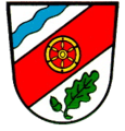
The community’s arms might be described thus: Argent a bend sinister gules surmounted by a wheel spoked of six of the first, in chief dexter a bend sinister wavy azure, in base sinister an oak sprig with a leaf in bend sinister and an acorn in bend vert.
The German blazon specifies a silver wheel (belegt mit einem sechsspeichigen silbernen Rad), although the example shown here has a golden wheel. This wheel – the Wheel of Mainz – and the bend sinister – the slanted stripe, so called because at the top it begins on the sinister (armsbearer’s left, viewer’s right) side – stand for the community’s history, lasting from the 13th century until 1803, as an Electoral Mainz holding; the tinctures gules and argent (red and silver) were Mainz’s colours. The blue wavy bend sinister stands for the community’s location at the forks of the Sailauf and the Steinbach, two local brooks. The green oak twig with the acorn refers to the Spessart range, which is thickly wooded with oaks, and in which the community lies.
The arms were conferred on 21 March 1969.
Culture and social life
Sailauf has a variety of clubs; nationally known are the Bavarian Red Cross Juniors.
Two events that are unique to Sailauf are the yearly Sailaufer Knoblauchfest (“Sailauf Garlic Festival”) and the Tsukahara-Festival.
Among social institutions there are a kindergarten and a primary school. The community is a member of the association of municipal music schools.
Verkehr
Sailauf verfügt über eine Anbindung an die A 3.
Famous people
- Felix Magath, footballer and trainer
- Bernhard Lippert, football trainer
- Theodor Bergmann, entrepreneur and carmaker
References
- ↑ "Fortschreibung des Bevölkerungsstandes". Bayerisches Landesamt für Statistik und Datenverarbeitung (in German). 31 December 2013.
Further reading
- Rudolf J. Lippert: Sailauf und Eichenberg im Lichte der Überlieferung. self-published, Obertshausen 2003
- Werner Konrad, Ferdl Kraus, Waldemar Lippert: Sailauf-Eichenberg. In Bildern um die Jahrtausendwende, Geiger-Verlag 2000
- Sailauf Eichenberg. Bilder aus über 100 Jahren dörflicher Vergangenheit, by Ferdinand Kraus (foreword), Fred Maier (foreword), Karl Strom (foreword), Gerhard Steigerwald (foreword), Maria Reinhardt, Herta Hubertus, Bruno Eisert, Gottfried Baumann, Geiger-Verlag 1996
External links
| Wikimedia Commons has media related to Sailauf. |
- Structural change in Sailauf 1939 to 1969 with Ausblick (German)
- Structural data 1998 (German)