Saharefo
| Saharefo | |
|---|---|
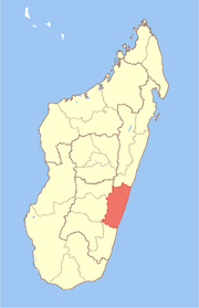
 Saharefo Location in Madagascar | |
| Coordinates: 21°40′S 47°41′E / 21.667°S 47.683°E | |
| Country |
|
| Region | Vatovavy-Fitovinany |
| District | Manakara |
| Elevation[1] | 226 m (741 ft) |
| Population (2001)[2] | |
| • Total | 12,000 |
| Time zone | EAT (UTC3) |
Saharefo is a town and commune in Madagascar. It belongs to the district of Manakara, which is a part of Vatovavy-Fitovinany Region. The population of the commune was estimated to be approximately 12,000 in 2001 commune census.[2]
Only primary schooling is available. The majority 99.7% of the population of the commune are farmers. The most important crop is rice, while other important products are bananas, coffee and cassava. Services provide employment for 0.3% of the population.[2]
References and notes
- ↑ Estimated based on DEM data from Shuttle Radar Topography Mission
- ↑ 2.0 2.1 2.2 "ILO census data". Cornell University. 2002. Retrieved 2008-05-03.
Coordinates: 21°40′S 47°41′E / 21.667°S 47.683°E