Saharat Thai Doem
| Saharat Thai Doem สหรัฐไทยเดิม | |||||
| Subdivision of Thailand | |||||
| |||||
|
Flag | |||||
 | |||||
| Capital | Kengtung | ||||
| Historical era | World War 2 | ||||
| - | Handover of the territory by the Japanese | 5 January 1942 | |||
| - | Reintegration of the territories into Burma | 1 January 1946 | |||
| Today part of | | ||||

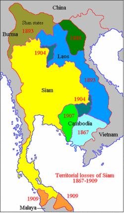
Saharat Thai Doem (Thai: สหรัฐไทยเดิม 'Unified former Thai Territories') is a former administrative division of Thailand. It encompassed the parts of Shan State and the Karenni States in British Burma annexed by the Thai government after the Japanese invasion of Burma.
By means of this annexation Axis-aligned Thailand expanded northwards to the 22nd parallel north and gained a border with China. Chiang Tung (Keng Tung) was the administrative headquarters of the province.[1]
Thailand was still allied with Japan when the war ended, but the United States proposed a solution. In 1946 Thailand agreed to hand back the territories occupied during Japanese presence in the country as the price for admission to the United Nations, consequently all wartime claims against Siam were dropped and the country received a substantial package of American aid.[2] Then the Thai-occupied region in Eastern Shan state returned to its pre-war status and became again part of Burma.
Geography
The territory of the Northern Thai province was mountainous, except for a few small areas, such as the intermontane basin of Kengtung. The Salween River marked the western border. The northernmost point was the frontier town of Pangsang.
There were few roads connecting the districts and most of the population lived in small mountain villages. The area was mostly inhabited by Tai Yai people, but there were also sizeable communities of Lahu, Akha and Wa people, as well as those belonging to the Karen ethnic group, including the Red Karen and the Kayan people.
History
Thai Prime Minister Plaek Phibunsongkhram signed a secret agreement with the Japanese Empire on 14 December 1941 and committed the Thai armed forces to participate in the planned Malayan Campaign and Burma Campaign. An alliance between Thailand and Japan was formally signed on 21 December 1941. On 25 January 1942, the Thai government, believing the Allies beaten, declared war on the United States and the United Kingdom. As a reward for entering into a military alliance with them, the Japanese agreed to return to Thailand Kedah, Perlis, Kelantan, and Terengganu, the four Malayan provinces ceded to the British in 1909, as well as parts of Shan State in British Burma that were deemed "lost territories" of Thailand.[3][4]
In accordance with the Thai military alliance with Japan that was signed on 21 December 1941, On 21 March, the Thais and the Japanese also agreed that the area of Eastern Shan State and Karenni States east of the Salween were to be under Thai administration. The remaining territories of Burma were to remain under Japanese control. On 10 May 1942, after the territories were officially transferred to Thailand by the Japanese, the Thai Phayap Army entered Burma's eastern Shan State, which had been claimed by Siamese kingdoms. Three Thai infantry and one cavalry division, spearheaded by armoured reconnaissance groups and supported by the air force, engaged the retreating Chinese 93rd Division. Kengtung town, the main objective, was captured on 27 May. Renewed offensives in June and November evicted the Chinese into Yunnan.[5] In December 1942 the Thai administration took over parts of Shan States, including Kengtung State and Möngpan which were annexed by Thailand on 1 August 1943.[6]
Field Marshall Phibunsongkhram made a visit to the new Northern Province in 1943. There he became aware of the acute problems of the Northern Army troops, which included lack of essentials and a high mortality rate which had peaked during the rainy season, owing mainly to malnutrition, malaria and dengue fever, rather than to deaths in batlle. Following Phibunsongkhram's visit, supplies were sent from Bangkok, including quinine, uniforms, bananas and sugar. Also staff officers and doctors were transferred to Shan State in order to lift the morale of the troops in the area.[7]
In order to communicate the annexed northern territory of Saharat Thai Doem with the rest of Thailand, a network of dirt roads totaling hundreds of kilometres across mountainous terrain was built with Japanese help on the orders of the Field Marshall. Some of these roads have endured to this day, such as the scenic loop on highway 1285 from Mae Hong Son to Chiang Mai via Pai, which is based on the original Phibunsongkhram's road system.[7]
Administration
A rudimentary administration was set up early in the invasion with Kengtung as the centre. Made up mostly of small rural communities, during the occupation the Thai territory in Shan State remained a largely forgotten place. Wounded or ill Thai soldiers who were sent to Bangkok were shocked that there was no knowledge or concern about the hardships of the Northern Thai Army.[7]
Authorities
Thai Military governor in Kengtung and Möngpan
- Dec 1942 - 1945 Phin Choonhavan (b. 1891 - d. 1973)
Administrative divisions
Saharat Thai Doem was divided into twelve districts (amphoe), to which later a further district was added.[8]
- Mueang Chiang Tung District (อำเภอเมืองเชียงตุง), parts of present-day Kengtung District
- Mueang Yong District (อำเภอเมืองยอง), now Mong Yawng Township
- Mueang Phayak District (อำเภอเมืองพยาค), parts of present-day Mong Hpayak District
- Mueang Yu District (อำเภอเมืองยู้),
- Mueang Ching District (อำเภอเมืองชิง),
- Mueang Ma District (อำเภอเมืองมะ),
- Mueang Yang District (อำเภอเมืองยาง), now Mong Yang Township
- Mueang Khak District (อำเภอเมืองขาก),
- Mueang Len District (อำเภอเมืองเลน),
- Mueang Ko District (อำเภอเมืองโก),
- Mueang Sat District (อำเภอเมืองสาด), now Mong Hsat Township
- Mueang Hang District (อำเภอเมืองหาง), now Mong Hang village, Mong Tong Township
- Mueang Phan District (อำเภอเมืองพาน), now Mong Pan Township of Loilen District
Historical events
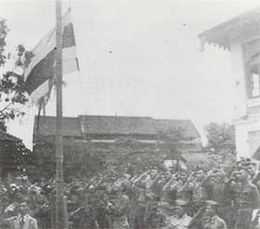 The Thai flag rises in Kengtung. |
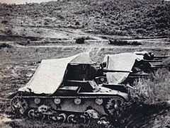 Thai tanks during a lull in the battles near Taunggyi. |
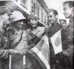 Thai and Japanese soldiers meet in Mandalay. Burma Campaign 1942 |
See also
References
- ↑ Ronald Bruce St. John, The Land Boundaries of Indochina: Cambodia, Laos and Vietnam, p. 20
- ↑ David Porter Chandler & David Joel Steinberg eds. In Search of Southeast Asia: A Modern History. p. 388
- ↑ "A Forgotten Invasion: Thailand in Shan State, 1941-45"
- ↑ "สงครามมหาเอเซียบูรพา - จากวันวีรไทย ถึง วันประกาศสงคราม". samphan. I See History dot com. September 2009. Retrieved 8 August 2010.
- ↑ Thailand and the Second World War at the Wayback Machine (archived October 27, 2009)
- ↑ Shan and Karenni States of Burma
- ↑ 7.0 7.1 7.2 Bangkok Post - A Forgotten Invasion: Thailand in Shan State, 1941-45 by Andrew Forbes in Axis History Forum
- ↑ "ประกาสกองบันชาการทหานสูงสุด เรื่องการปกครองสหรัถไทยเดิม" (PDF). ราชกิจจานุเบกสา (in Thai) 60 (31ก): 1082–1083. 15 มิถุนายน พ.ศ. 2486. Check date values in:
|date=(help)
External links
- WWII, Cold War and Thailand
- World War 2 campaigns in Burma (in Thai)
- The Land Boundaries of Indochina: Cambodia, Laos and Vietnam
- Annexed territories (in Thai)
- Manifesto for Greater East Asian Co-operation
| ||||||||||||||||||||