Sagiada
| Sagiada Σαγιάδα | |
|---|---|
 Sagiada | |
|
Location within the regional unit 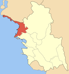 | |
| Coordinates: 39°38′N 20°11′E / 39.633°N 20.183°ECoordinates: 39°38′N 20°11′E / 39.633°N 20.183°E | |
| Country | Greece |
| Administrative region | Epirus |
| Regional unit | Thesprotia |
| Municipality | Filiates |
| Population (2001)[1] | |
| • Rural | 897 |
| • Municipal unit | 2,160 |
| Time zone | EET (UTC+2) |
| • Summer (DST) | EEST (UTC+3) |
| Vehicle registration | ΗΝ |
Sagiada (Greek: Σαγιάδα) is a village and a former municipality in Thesprotia, Epirus, Greece. Since the 2011 local government reform it is part of the municipality Filiates, of which it is a municipal unit.[2] In 2001 its population was 897 for the village and 2,160 for the municipal unit. The seat of the municipality was in Asprokklisi. Sagiada stretches between the Ionian Sea to the west and Albania to the north. It is the westernmost point of mainland Greece. The river Thyamis flows into sea 4 km south of the village Sagiada. There are plains in the southern part of the municipal unit, and mountains on the Albanian border. The village Sagiada is 10 km west of Filiates, 15 km northwest of Igoumenitsa and 4 km south of the Albanian town of Konispol.
Subdivisions
The former municipal unit of Sagiada was subdivided into the following communities:
- Sagiada
- Asprokklisi
- Kestrini
- Ragi
- Smertos
References
- ↑ De Facto Population of Greece Population and Housing Census of March 18th, 2001 (PDF 39 MB). National Statistical Service of Greece. 2003.
- ↑ Kallikratis law Greece Ministry of Interior (Greek)
 |
Xarrë (Albania) | Konispol (Albania) | | |
| Ionian Sea | |
Filiates | ||
| ||||
| | ||||
| Igoumenitsa |
| ||||||||||