Sagay, Camiguin
| Sagay | |
|---|---|
| Municipality | |
|
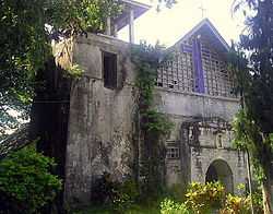
Sagay Church | |
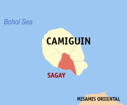
 Map of Camiguin with Sagay highlighted | |
.svg.png) Sagay Location within the Philippines | |
| Coordinates: 09°07′N 124°43′E / 9.117°N 124.717°ECoordinates: 09°07′N 124°43′E / 9.117°N 124.717°E | |
| Country | Philippines |
| Region | Northern Mindanao (Region X) |
| Province | Camiguin |
| District | Lone district |
| Founded | July 31, 1909 |
| Barangays | 9 |
| Government[1] | |
| • Mayor | Eugenio G. Ong |
| Area[2] | |
| • Total | 44.13 km2 (17.04 sq mi) |
| Population (2010)[3] | |
| • Total | 11,873 |
| • Density | 270/km2 (700/sq mi) |
| Time zone | PST (UTC+8) |
| ZIP code | 9103 |
| Dialing code | 88 |
Sagay is a fifth class municipality in the province of Camiguin, Philippines. According to the 2010 census, it has a population of 11,873 people.[3]
History
The town square of Sagay includes a British cannon. This cannon has been dated at 1707, and is a nine-pounder Demi-Culverin. It can clearly be identified as British by the emblem on the top which includes the Tudor rose. It was possibly left behind in 1763 after the siege of Manila, and perhaps was brought to Camiguin by the Spanish to defend against Moro raiders.
In 1909, the municipality of Sagay was created. Prior to this date, Sagay town had been a part of the municipality of Catarman. Initially, Sagay municipality included the town of Guinsiliban, but that later became a municipality in its own right.
In 1942, the Japanese Occupation forces entered the town of Sagay, Camiguin.
In 1945, the town of Sagay was liberated by the invasion of the Filipino forces of the 6th and 10th Infantry Division of the Philippine Commonwealth Army who attacked the Japanese Imperial forces during the Battle of Camiguin at the end of World War II.
Barangays
Sagay is politically subdivided into 9 barangays.[2]
- Alangilan
- Bacnit
- Balite
- Bonbon
- Bugang
- Cuña
- Manuyog
- Mayana
- Poblacion
Demographics
| Population census of Sagay | ||
|---|---|---|
| Year | Pop. | ±% p.a. |
| 1990 | 9,494 | — |
| 1995 | 9,243 | −0.50% |
| 2000 | 10,356 | +2.47% |
| 2007 | 11,198 | +1.08% |
| 2010 | 11,873 | +2.15% |
| Source: National Statistics Office[3][4] | ||
References
- ↑ "Municipalities". Quezon City, Philippines: Department of the Interior and Local Government. Retrieved 30 January 2013.
- ↑ 2.0 2.1 "Province: Camiguin". PSGC Interactive. Makati City, Philippines: National Statistical Coordination Board. Retrieved 30 January 2013.
- ↑ 3.0 3.1 3.2 "Total Population by Province, City, Municipality and Barangay: as of May 1, 2010". 2010 Census of Population and Housing. National Statistics Office. Retrieved 30 January 2013.
- ↑ "Province of Camiguin". Municipality Population Data. LWUA Research Division. Retrieved 16 August 2013.
External links
| Wikimedia Commons has media related to Sagay, Camiguin. |
 |
Mambajao | Mahinog |  | |
| Catarman | |
Guinsiliban | ||
| ||||
| | ||||
| Bohol Sea |
| ||||||||||
