Sabine National Wildlife Refuge
| Sabine National Wildlife Refuge | |
|---|---|
|
IUCN category IV (habitat/species management area) | |
 Map of the United States | |
| Location | Cameron Parish, Louisiana |
| Nearest city | Hackberry, Louisiana |
| Coordinates | 29°54′N 93°32′W / 29.900°N 93.533°WCoordinates: 29°54′N 93°32′W / 29.900°N 93.533°W |
| Area | 124,511 acres or 503.88 km2 |
| Established | 1937 |
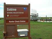
| Visitors | open to public |
| Governing body | U.S. Fish and Wildlife Service |
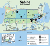
Sabine National Wildlife Refuge (established in 1937) is a National Wildlife Refuge located in Cameron Parish in southwestern Louisiana. It is on Louisiana State Route 27, 8 miles (13 km) south of Hackberry and 12 miles (19 km) north of Holly Beach. The western boundary of the Sabine refuge is Sabine Lake, the inlet for Port Arthur, Texas, while the tip of the eastern end reaches Calcasieu Lake.
Southwest Louisiana National Wildlife Refuge Complex
The Southwest Louisiana National Wildlife Refuge Complex was formed by administratively combining of the Lacassine National Wildlife Refuge, Cameron Prairie National Wildlife Refuge, Shell Keys National Wildlife Refuge, and the Sabine NWR in 2004.[1]
Wildlife and habitat

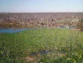
Sabine is a 124,511-acre (504 km2) sanctuary, the largest coastal marsh refuge on the Gulf Coast of the United States. It is home to more than 200 species of birds, including ducks, great egrets, geese, Neotropic cormorants, raptors, snowy egrets, wading birds, and shorebirds. There is also a very large contingent of American alligators, as well as blue crabs, American mink, muskrats, coypu, North American river otters, rabbits, shrimp, and turtles.
Located at the visitor center is a pamphlet that explains the "Wetland Walkway", a 1.5-mile (2.4 km) nature trail made from concrete, a portion of which is a wooden boardwalk, located 4 miles (6.4 km) south of the refuge headquarters (HQ). It includes an observation tower, and it has 15 knowledge stations, to acquaint and educate, the visitor with the Gulf Coast marsh. There is a second natural trail, "Blue Goose Trail", north of the camp HQ, that is a 1-mile (1.6 km) round trip with a scenic overlook.
Petroleum exploration is allowed on the refuge. There was an oil spill at one of the well sites in Sabine during the winter of 2002-2003. Most of the spill was cleaned up by burning the oil.
Hurricane damage
Sabine NWR was in the direct path of Hurricane Rita on September 24, 2005 and as a result the National Wildlife Refuge was closed to all public uses because of damages sustained during the hurricane but has now reopened.
All of the office buildings, visitor center and maintenance shops were damaged beyond repair and have been removed. There are three remaining structures at the Sabine NWR headquarters area that will be repaired: boathouse, a block storage building and a tin-covered storage shed.
Refuge recreational areas along Highway 27 received varying amounts of damage to bridges, piers, observation towers, boardwalks, restroom facilities, fences, and parking lots. These facilities need to be repaired before the areas can be re-opened for public use. Refuge staff is working with state and local partners, contractors, and other federal agencies to have these repairs completed.
West of Highway 27, Sabine refuge canals and marshes were severely affected by storm wind and water. Approximately 32,000 acres (130 km2) of refuge marshes, levees, and canals were damaged. Canals and marshes are clogged with seven million cubic meters of debris from off shore rigs and coastal communities. There are both physical and chemical hazards present throughout the refuge, many of which have settled below the marsh and water surfaces. Tanks and barrels containing hazardous liquids and gases have the potential to explode or break down and release toxins into the environment. Over 1,400 hazardous material containers have been identified and are estimated to contain between 115,000 and 350,000 gallons of hazardous liquids and gases.
Stats
- Location: 29°54′N 93°32′W / 29.900°N 93.533°W
- Elevation: 10 feet (3 m; avg)
- Area:
- Water: 39,844 acres (161 km2)
- Grassland/herbaceous/marsh: 84,667 acres (343 km2)
- Annual visitors: 300,000 (approximately)
See also
| Wikimedia Commons has media related to Sabine National Wildlife Refuge. |
- List of National Wildlife Refuges: Louisiana
References
- ↑ "Southwest Louisiana NWR Complex". U.S. Fish and Wildlife Service. Retrieved July 12, 2014.
![]() This article incorporates public domain material from the United States Government document "U.S. Fish and Wildlife Service ".
This article incorporates public domain material from the United States Government document "U.S. Fish and Wildlife Service ".
External links
- Sabine NWR @ the U.S. Fish & Wildlife Service
- Bird Checklists of Sabine NWS from USGS's Northern Prairie Wildlife Research Center
- Sabine NWR oil spill @ NOAA
| ||||||||||||||||||||||||||||||||||||||||||||||||||||||||||||