SS Wairarapa
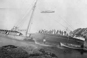
 The wreck some days after the accident. | |
| Career (New Zealand) | |
|---|---|
| Name: | SS Wairarapa |
| Namesake: | Wairarapa |
| Owner: | Union Steam Ship Company |
| Operator: | Union Steam Ship Company |
| Route: | Sydney-Auckland |
| Builder: | William Denny and Brothers |
| Yard number: | 259 |
| Launched: | 19 May 1882 |
| Completed: | 3 July 1882 |
| Out of service: | 29 October 1894 |
| Homeport: | Auckland |
| Fate: | Wrecked off Miners Head |
| General characteristics | |
| Class and type: | Luxury steamer |
| Type: | Steel screw steamship |
| Tonnage: | 1786 gross tons, 1023 net tons |
| Length: | 285.2 ft |
| Beam: | 36.3 ft |
| Draught: | 23.7 ft |
| Speed: | ~14 knots |
The SS Wairarapa was a New Zealand ship of the late 19th century plying the route between the Auckland, New Zealand and Australia. It came to tragic fame when it hit a reef at the northern edge of Great Barrier Island, about 100 km out from Auckland, and sank. The death toll of around 140 people remains one of the largest such losses in the country's history.[1] The ship was named for the Wairarapa region.
Wrecking
The Wairarapa was built in Dumbarton, Scotland in 1882 for the Union Steam Ship Company. Soon after launch she sailed to New Zealand to become one of a small number of luxury steamers plying the route across the Tasman Sea to Australia.
The Wairarapa sailed from Sydney, Australia on Wednesday 24 October 1894. The ship’s destination was the rapidly growing New Zealand port city of Auckland, 2,000 miles away. As the Wairarapa rounded the top of the North Island of New Zealand four days later, fog and storms set in. However, Captain John S. McIntosh refused to slow the ship from 13 knots, nearly full speed despite the thick fog. Fatally, the ship went off-course, possibly due to a faulty compass bearing. At the subsequent Court of Enquiry into the incident, some even suggested the ship had been steered by dead reckoning rather than using a compass at all. Whatever the cause, the ship skirted to the west of the Poor Knights Islands, not the east. As a consequence she was much closer to the mainland than the ship’s crew believed.
At around 8 minutes past midnight on Monday 29 October 1894, the ship was wrecked on the steep cliffs near Miners Head on the northern tip of Great Barrier Island, off the coast of Auckland.[2]
The hours after the wreck saw great loss of life. Many passengers could not swim and drowned in the rough seas in trying to make it to shore. One liferaft was seen floating out to sea and was never sighted again. Many men, including a large portion of the crew, took to one of the lifeboats, leaving women and children behind. A number of people took refuge in the ship’s rigging. At about 3 am Captain McIntosh jumped into the sea and was presumed drowned. Several other lifeboats which had been safely launched stayed near the stricken ship and picked survivors from the sea where possible.
One lifeboat eventually succeeded in reaching a local community of Ngati Wai Māori based at Katherine Bay, on the western coast of the island. They were able to rescue and provide care for a number of the survivors.
Although the Wairarapa was expected in Auckland, there was no way of knowing where she may have come to grief. As the only contact with the island at the time was via weekly trips from a steamer, it was three full days until news of the shipwreck reached Auckland.
The Northern Company's steamer Argyle arrived in Port FitzRoy on Wednesday 31 October and took the survivors who had reached Port FitzRoy on board. The steamer then proceeded to the site of the shipwreck, and to Katherine Bay, picking up further survivors and sailing back to arrive in Auckland about 3am Thursday 1 November.
A Court of Enquiry was held after the Wairarapa disaster, and found Captain McIntosh's actions were the primary cause of the tragedy.
Protection
The wreck of the Wairarapa is scheduled for preservation in the Auckland Regional Plan: Coastal and is also protected under the archaeological provisions of the Historic Places Act 1993.
References
- ↑ Historic SS Wairarapa Graves (from the DOC. Accessed 2008-06-04.)
- ↑ "Eight Minutes Past Midnight", Steve Locker-Lampson & Ian Francis, Rowfant Books, Wellington New Zealand, 1981
External links
- Ancestr.com: October 29th 1894 - The Tragedy of the SS Wairarapa
- http://tvnz.co.nz/descent-from-disaster/s1-ep4-video-5519154 - The New Zealand docmentary series Decent from disaster made and episode about this wreck.
Coordinates: 36°04′03″S 175°21′07″E / 36.0674°S 175.3519°E