São Miguel, Cape Verde
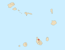
São Miguel is a concelho (municipality) of Cape Verde. It is situated in the northeastern part of the island of Santiago. Its seat is the town Calheta de São Miguel. Its population was 15,630 at the 2010 census.[1]
Subdivisions
The municipality consists of one freguesia (civil parish), São Miguel Arcanjo. The freguesia is subdivided into the following settlements:
- Achada Monte
- Calheta de São Miguel
- Casa Branca
- Chã de Ponta
- Cutelo Gomes
- Espinho Branco
- Gongon
- Igreja
- Machado
- Mato Correia
- Monte Bode
- Monte Pousada
- Palha Carga
- Pedra Barro
- Pedra Serrado
- Pilão Cão
- Pingo Chuva
- Ponta Verde
- Principal
- Ribeireta
- Tagarra
- Varanda
- Veneza
- Xaxa
History
The municipality was created in 1991, when a parish of the older Municipality of Tarrafal was separated to become the Municipality of São Miguel.
Demography
| Population of São Miguel (1990—2010) |
|---|
| 1990[2] |
2000[3] |
2010[1] |
| 13787 |
16128 |
15630 |
External links
References
|
|---|
| | Barlavento Islands | |
|---|
| | Sotavento Islands | |
|---|
|
The island of Santiago and the surrounding islands |
|---|
| Communities and
settlements | |
|---|
| | Mountains | |
|---|
| | Municipalities | |
|---|
| | Parishes | |
|---|
|