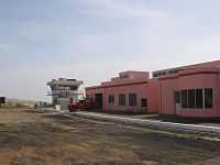
São Filipe Airport
São Filipe Airport (Portuguese Aeródromo de São Filipe) (IATA: SFL, ICAO: GVSF) is Cape Verde's fourth most-used airport located in the island of Fogo, it is located southeast of the town of São Filipe via the road linking directly from the town and is near the Atlantic Ocean and serves the entire island. The last two letters of the ICAO code represents São Filipe.
In May 2011, its runway was extended to 1,500 meters by 30 meters wide from the previous length of 1,197 meters by 20 meters wide, in order to accommodate bigger planes such as "ATR 42" and "ATR 72", upon landing and taking off or taxiing. The totality of the airport's terminal went through complete remodeling, followed by the extension of its runway. The airport was inaugurated in the mid to late-20th century.
Airlines and destinations
External links
See also
|
|---|
| | International | |
|---|
| | Domestic | |
|---|
| | Defunct | |
|---|
|