Rushup Edge
| Lord's Seat (Rushup Edge) | |
|---|---|
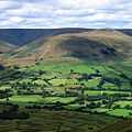
 Rushup Edge towards Lord's Seat | |
| Elevation | 546 m (1,791 ft)[1] |
| Location | |
| Location | Derbyshire, England |
| Range | Peak District |
| OS grid | SK113834 |
| Topo map | OS Landranger 110 |
Rushup Edge is a ridge in the Derbyshire Peak District of England. The ridge's highest point is Lord's Seat at 546 m (1,791 ft), while Mam Tor lies at its eastern end, beyond which the Great Ridge runs.
Lord's Seat is a round barrow.[2]
Geology
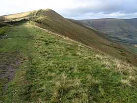
Rushup Edge is part of the ridge which extends east to Mam Tor, Hollins Cross, Back Tor and Lose Hill, separating the Edale and Hope valleys. The ridge is formed of Namurian (c320mya) age Mam Tor Beds (alternating sandstone and siltstone) and landslides on the north have formed colluvium.[3]
Protest
In October 2014, mountain bikers, walkers, horse riders, climbers and conservationists held a protest against Derbyshire County Council maintenance work on the byway that runs along Rushup Edge. They were upset at the insensitive nature of the work, the cost, the environmental impact and the apparent lack of consultation with them before works began. Derbyshire County Council halted the work to speak with protesters in December 2014.
See also
- Rushop, also known as Rushup, a nearby village
References
- ↑ http://www.mountain-forecast.com/peaks/Rushup-Edge
- ↑ The Buildings of England - Derbyshire - Castleton: Nikolaus Pevsner 1953
- ↑ The Mam Tor landslide, geology & mining legacy around Castleton LAURANCE DONNELLY 2006
External links
Geograph 1:50,000 map and photos
| |||||||||||||||||