Rural Municipality of Reno No. 51
| Reno No. 51 | |
|---|---|
| Rural Municipality | |
|
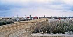
View of Robsart from the Robsart Hospital | |
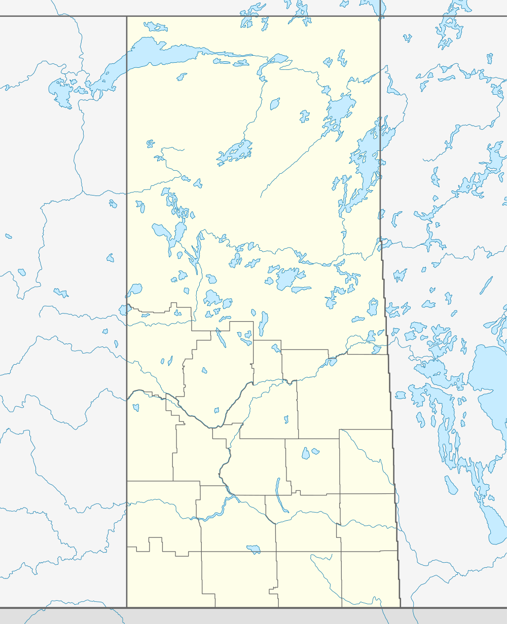 Location of Reno No. 51 in Saskatchewan | |
| Coordinates: 49°15′41″N 109°33′34″W / 49.26139°N 109.55944°WCoordinates: 49°15′41″N 109°33′34″W / 49.26139°N 109.55944°W | |
| Country | Canada |
| Province | Saskatchewan |
| Region | Southwest Saskatchewan |
| Census division | 4 |
| Government[1] | |
| • Governing body | Reno No. 51 Council |
| • Municipal seat | Consul |
| • Reeve | Brian McMillan |
| • Administrator | Kim Lacelle |
| Population (2006) | |
| • Total | 462 |
| • Density | 0.1/km2 (0.3/sq mi) |
| • Dwellings | 235 |
| Time zone | UTC (UTC-6) |
| Area code(s) | 306 |
| Highways |
Highway 13 Highway 18 Highway 21 Highway 615 |
| Waterways |
Cypress Lake Battle Creek Middle Creek Lodge Creek |
| Website | Official website |
Reno No. 51 is a rural municipality in the Canadian province of Saskatchewan, located in the Census Division 4, just north of the USA border, and east of the Alberta border, in the southwestern corner of the province. The seat of the municipality is located in the village of Consul. The RM borders the RMs of Maple Creek No. 111, White Valley No. 49, and Frontier No. 19, as well as Cypress County in southeastern Alberta, and Hill County and Blaine County in Montana.
Demographics
In 2006, the Rural municipality had a population of 462 in 235 dwellings, a 1.1% increase from 2001. On a surface of 3,460.66 km² it has a density of 0.1 inhabitants/km².[2]
Statistics
| |||||||||||||||||||
Communities
The following communities are located in this municipality:
- Villages
- Consul - Seat of municipality
- Localities[6]
- Altwan
- Battle Creek
- Govenlock, dissolved as a village January 1, 1976
- Merryflat
- Nashlyn
- Notukeu
- Oxarat
- Palisade
- Rangeview
- Robsart, dissolved as a village January 1, 2002.[7]
- Senate, dissolved as a village January 1, 1994
- Supreme
- Tyro
- Vidora, dissolved as a village January 1, 1952, former seat of the municipality.
- West Plains
- Willow Creek
Transportation
The following is a list of Saskatchewan highways and provincial roads, railways, and other forms of transportation that service the area.
- Highway 13
- Highway 18
- Highway 21
- Highway 615
- Highway 271
- Great Western Railway, a Canadian short line railway company operating on former Canadian Pacific Railway trackage in southwest Saskatchewan.
Attractions
Local Attractions;
- Red Coat Trail
- Old Man on His Back Prairie and Heritage Conservation Area
- Cypress Lake
- Cypress Lake Provincial Recreation Site
- Heglund Island Provincial Wildlife Refuge
Regional Attractions;
- T.rex Discovery Centre,[8] Eastend
- Cypress Hills
Climate
| Climate data for WILLOW CREEK, SK (~Southwestern Reno No. 51, 1971-2000 Normals) | |||||||||||||
|---|---|---|---|---|---|---|---|---|---|---|---|---|---|
| Month | Jan | Feb | Mar | Apr | May | Jun | Jul | Aug | Sep | Oct | Nov | Dec | Year |
| Average high °C (°F) | −5.4 (22.3) |
−1.6 (29.1) |
4.8 (40.6) |
13.5 (56.3) |
19.3 (66.7) |
24.1 (75.4) |
27.8 (82) |
27.7 (81.9) |
20.9 (69.6) |
13.3 (55.9) |
2.3 (36.1) |
−3.3 (26.1) |
12 (54) |
| Average low °C (°F) | −17.8 (0) |
−14.4 (6.1) |
−7.8 (18) |
−1.8 (28.8) |
3.9 (39) |
8.3 (46.9) |
10.6 (51.1) |
9.8 (49.6) |
3.8 (38.8) |
−2.2 (28) |
−10 (14) |
−16.1 (3) |
−2.8 (27) |
| Average precipitation mm (inches) | 12.4 (0.488) |
7.8 (0.307) |
16 (0.63) |
15.6 (0.614) |
47.1 (1.854) |
60.6 (2.386) |
41.3 (1.626) |
30.9 (1.217) |
32.3 (1.272) |
16.3 (0.642) |
17 (0.67) |
16.6 (0.654) |
313.8 (12.354) |
| Source: Environment Canada[9] | |||||||||||||
See also
References
- ↑ Official website http://www.municipal.gov.sk.ca/apps/Pub/MDS/muniDetails.aspx?cat=10&mun=2527
- ↑ 2006 Community Profiles http://www12.statcan.ca/english/census06/data/profiles/community/Details/Page.cfm?B1=All&Code1=4704019&Code2=47&Custom=&Data=Count&Geo1=CSD&Geo2=PR&Lang=E&SearchPR=01&SearchText=Ren+No.+51&SearchType=Begins
- ↑ "2011 Community Profiles". Canada 2011 Census. Statistics Canada. July 5, 2013. Retrieved 2009-02-24.
- ↑ "2006 Community Profiles". Canada 2006 Census. Statistics Canada. March 30, 2011. Retrieved 2009-02-24.
- ↑ "2001 Community Profiles". Canada 2001 Census. Statistics Canada. February 17, 2012. Retrieved 2011-09-16.
- ↑ Standard Geographical Classification (SGC) 2001
- ↑ "Covered population 2002" (PDF). Saskatchewan Health. Retrieved 2008-04-17.
- ↑ T. rex Discovery Centre, Eastend, Saskatchewan
- ↑ "Canadian Climate Normals 1971-2000 Station Data". Environment Canada. Retrieved November 11, 2013.