Rural City of Ararat
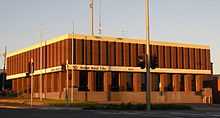
Ararat Rural City Council offices – 21 Vincent Street, Ararat
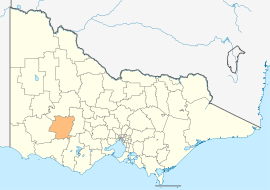
The Rural City of Ararat is a local government area in Victoria, Australia, located in the western part of the state. It covers an area of 4,230 square kilometres (1,630 sq mi) and, at the 2011 Census, had a population of 11,183.[1] It includes the towns of Ararat, Armstrong, Dunneworthy, Lake Bolac, Moyston, Pomonal, Streatham, Tatyoon, Wickliffe and Willaura. It was formed in 1994 from the amalgamation of the City of Ararat, Shire of Ararat and parts of the Shire of Mortlake and Shire of Stawell.[2][3]
The Rural City is governed and administered by the Ararat Rural City Council; its seat of local government and administrative centre is located at the council headquarters in Ararat. The Rural City is named after the main urban settlement located in the north of the LGA, that is Ararat, which is also the LGA's most populous urban centre with a population of 8,076.[4]
Council
Current composition
The council is composed of seven councillors elected to represent an unsubdivided municipality.[5]
| Ward | Councillor | Notes |
| Unsubdivided |
| Gwenda Allgood | |
| | Ian Harris | |
| | Fay Hull | |
| | Gary Hull | |
| | Colin McKenzie | |
| | Ian Wilson | (resigned on 4 November 2013)[6] |
| | Paul Hooper | Mayor (2013–14) |
|
Administration and governance
The council meets in the council chambers at the council headquarters in the Ararat Municipal Offices, which is also the location of the council's administrative activities. It also provides customer services at its administrative centre in Ararat.
See also
- List of localities (Victoria)
References
- ↑ 1.0 1.1 Census QuickStats (2011). "Ararat (RC) – LGA20260". Australian Bureau of Statistics. Government of Australia. Retrieved 10 January 2014.
- ↑ 2.0 2.1 Victoria Government Gazette – Online Archive (1837–1997). "S63 of 1994". State Library of Victoria. State Government of Victoria (published 23 September 1994). pp. 23–29. Retrieved 10 January 2014.
- ↑ Victoria Government Gazette – Online Archive (1837–1997). "S4 of 1995". State Library of Victoria. State Government of Victoria (published 20 January 1995). pp. 2–3. Retrieved 10 January 2014.
- ↑ Census QuickStats (2011). "Ararat (SS) – SSC20024". Australian Bureau of Statistics. Government of Australia. Retrieved 10 January 2014.
- ↑ Local Government in Victoria. "Ararat Rural City Council". Department of Transport, Planning and Local Infrastructure. State Government of Victoria. Retrieved 10 January 2014.
- ↑ Holwell, Jodie (8 November 2013). "Ararat's former mayor Ian Wilson resigns". The Ararat Advertiser. Fairfax Regional Media. Retrieved 10 December 2013.
External links
Coordinates: 37°17′00″S 142°55′00″E / 37.28333°S 142.91667°E / -37.28333; 142.91667