Rupganj Upazila
| Rupganj রূপগঞ্জ | |
|---|---|
| Upazila | |
|
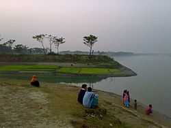
Shitalakshya River from Rupganj, Bangladesh | |
 Rupganj Location in Bangladesh | |
| Coordinates: 23°47.6′N 90°31′E / 23.7933°N 90.517°ECoordinates: 23°47.6′N 90°31′E / 23.7933°N 90.517°E | |
| Country |
|
| Division | Dhaka Division |
| District | Narayanganj District |
| Area | |
| • Total | 247.97 km2 (95.74 sq mi) |
| Population (1991) | |
| • Total | 375,935 |
| • Density | 1,516/km2 (3,930/sq mi) |
| Time zone | BST (UTC+6) |
| Website | Official Map of Rupganj |
Rupganj (Bengali: রূপগঞ্জ) is an Upazila of Narayanganj District in the Division of Dhaka, Bangladesh.
Geography
Rupganj is located at 23°47′35″N 90°31′00″E / 23.7931°N 90.5167°E . It has 64902 units of house hold and total area 247.97 km².
Sikder Group of Companies Ltd.
Demographics
As of the 1991 Bangladesh census, Rupganj has a population of 375935. Males constitute 53% of the population, and females 47%. This Upazila's eighteen up population is 187590. Rupganj has an average literacy rate of 37.9% (7+ years), and the national average of 32.4% literate.[1]
See also
References
- ↑ "Population Census Wing, BBS.". Archived from the original on 2005-03-27. Retrieved November 10, 2006.
