Rumeli Feneri
 | |
 | |
| Location | Rumelifeneri, Sarıyer in Istanbul Province, Turkey |
|---|---|
| Coordinates | 41°14′05″N 29°06′46″E / 41.23472°N 29.11278°ECoordinates: 41°14′05″N 29°06′46″E / 41.23472°N 29.11278°E |
| Year first constructed | 1856[1] |
| Year first lit | 1856[1][2] |
| Construction | Masonry |
| Tower shape | Two-staged octagonal prism[3] |
| Markings / pattern | White[3] |
| Height | 30 m (98 ft)[2][4] |
| Focal height | 58 m (190 ft)[5] |
| Range | 18 nmi (33 km)[2][4][5] |
| Characteristic | White group flashing every 12 seconds[5] |
| Admiralty number | E4956[3] |
| NGA number | 17496[3] |
| ARLHS number | TC1RLH[6] |
| Turkey number | TUR-053[6] |
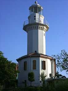
Rumeli Feneri, aka Türkeli Feneri, a historical lighthouse still in use, is located on the European side of Bosphorus' Black Sea entrance in Istanbul, Turkey. Rumeli (or Rumelia) is the former name for the Turkish lands in Europe. It is across from the Anadolu Feneri lighthouse, which is on the Asian side of the strait at a distance of 2 nmi (3.7 km). In Greek myth of Jason and the Golden Fleece, the two islets these lighthouses were built were called the Symplegades. They clashed together randomly, destroying any ship who passed between them. A line connecting the two lighthouses marks the northern boundary of the Port of Istanbul. The place where the lighthouse is erected is named Rumelifeneri, which today is a fishermen's village in Sarıyer district.[2][5]
The lighthouse was built by the French in order to provide safe navigation for the French and British war ships entering the Istanbul Strait from Black Sea during the Crimean War (1853–1856). The lighthouse went in service on May 15, 1856, together with its counterpart.[1][2] It was run by the French until 1933 when the 100-year concession was cancelled and the Turkish authorities took over.[2] Today, it is maintained by the Coastal Safety Authority (Turkish: Kıyı Emniyeti Genel Müdürlüğü) of the Ministry of Transport and Communication.[7]
The lighthouse is situated on a hillside 58 m (190 ft) high above the sea level and the entirely white painted tower has a height of 30 m (98 ft).[2] It is the tallest lighthouse in Turkey.[1][4] The tower has the form of a two-staged octagonal prism.[3] Initially, it was lit by kerosene that was later replaced by Dalén light using carbide (acetylene gas). Today, the light source is electricity, however, a butane gas lighting system is also installed for backup purposes. The Fresnel lens with 500 mm (1.6 ft) focal length allows the white light that group flashes every 12 seconds, a range of 18 nmi (33 km).[4][5]
The lighthouse is listed in Turkey under the code "TUR-053" and its radio call sign is TC1RLH.[6]
Rumeli Feneri is open to public visit as a historical site.[8]
References
- ↑ 1.0 1.1 1.2 1.3 "Rumelifeneri" (in Turkish). Rumelifeneri webpage. Retrieved 2010-06-06.
- ↑ 2.0 2.1 2.2 2.3 2.4 2.5 2.6 Yağcı, Ahmet Gökhan. "Deniz Fenerleri" (in Turkish). Türk Denizcilik Portalı. Archived from the original on 2010-05-29. Retrieved 2010-06-07.
- ↑ 3.0 3.1 3.2 3.3 3.4 Rowlett, Russ. "Lighthouses of Northwestern Turkey". The Lighthouse Directory. University of North Carolina at Chapel Hill. Retrieved 2010-09-15.
- ↑ 4.0 4.1 4.2 4.3 "Rumeli Türkeli Feneri" (in Turkish). Deniz Fenerleri. Retrieved 2010-06-06.
- ↑ 5.0 5.1 5.2 5.3 5.4 "Free Topo Maps-My Topo". Map Server. Retrieved 2010-06-14.
- ↑ 6.0 6.1 6.2 "Istanbul Lighthouses On The Air (ILOTA) Award by TCSWAT". TCSWAT. Retrieved 2010-05-05.
- ↑ "Tarihi Fenerler" (in Turkish). Kıyı Emniyeti Genel Müdürlüğü. Retrieved 2010-06-06.
- ↑ "Turizme Açılan Fenerler" (in Turkish). Kıyı Emniyeti Genel Müdürlüğü. Retrieved 2010-06-06.
Notes
- Tutel, Eser (1993). "Rumeli Feneri". Istanbul ansiklopedisi: dünden bügüne (in Turkish) 6. Kültür Bakanlığı/Tarih Vakfı. p. 354. ISBN 975-7306-00-2.
| ||||||||||||||||||||||||||||||||||||||||||||||||||||