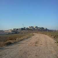
Rumana, Israel
| Rumana רומאנה رمانة | |
|---|---|
 | |
 Rumana | |
| Coordinates: 32°47′17″N 35°18′38″E / 32.78806°N 35.31056°ECoordinates: 32°47′17″N 35°18′38″E / 32.78806°N 35.31056°E | |
| Grid position | 179/243 PAL |
| District | Northern |
| Council | al-Batuf |
| Population (2011) | 1,034 |
| Name meaning | "The Pomegranate" (Rimmon)[1] |
Rumana (Arabic: رمانة; Hebrew: רֻמָּנָה, רומאנה) is an Arab village in northern Israel. Located near Nazareth, it falls under the jurisdiction of al-Batuf Regional Council. In 2011 it had a population of 1,034.[2]
History
The SWP found cisterns and rock-cut caves, and traces of ancient remains at this village.[3]
It has been suggested that Rumana was Romette, a casuale belonging to the Knights Hospitallers in the Crusader era.[4][5]
Ottoman era
Rumana, like the rest of Palestine, was incorporated into the Ottoman Empire in 1517, and in the census of 1596, the village was located in the nahiya of Tabariyya in the liwa of Safad. It had a population of 9 households, all Muslim. The villagers paid taxes on wheat, barley, fruit trees, cotton, goats and beehives.[6] Pierre Jacotin called the village Roumani on his map in 1799.[7]
Biblical scholar Edward Robinson passed by the village in 1852, and assumed it was the ancient Rimmon of the Tribe of Zebulun.[8] French explorer Victor Guérin described the village in the 1870s as being small, and protected from the outside by a continuous wall, and hedges of cactus. He also found many fine remains from former times and also speculates that it might be the Biblical site of Rimon, which is mentioned in the Book of Joshua.[9] (Joshua 19:13) In Palestine Exploration Fund's 1881 Survey of Western Palestine, the village (called Rummaneh) was described as:
A small village built of stone, and containing about 70 Moslems. It is situated on a low ridge above the plain, and there are a few olive-trees around. The water supply is from cisterns and a well.[10]
British Mandate era
In a the 1922 census of Palestine conducted by the British Mandate authorities, Rummaneh had a population of 37, of which 33 were Muslims and 4 Christians.[11] The Christians were all Melkite.[12] The population had increased sharply in the 1931 census to 197; 195 Muslim and 2 Christians, in a total of 36 houses.[13]
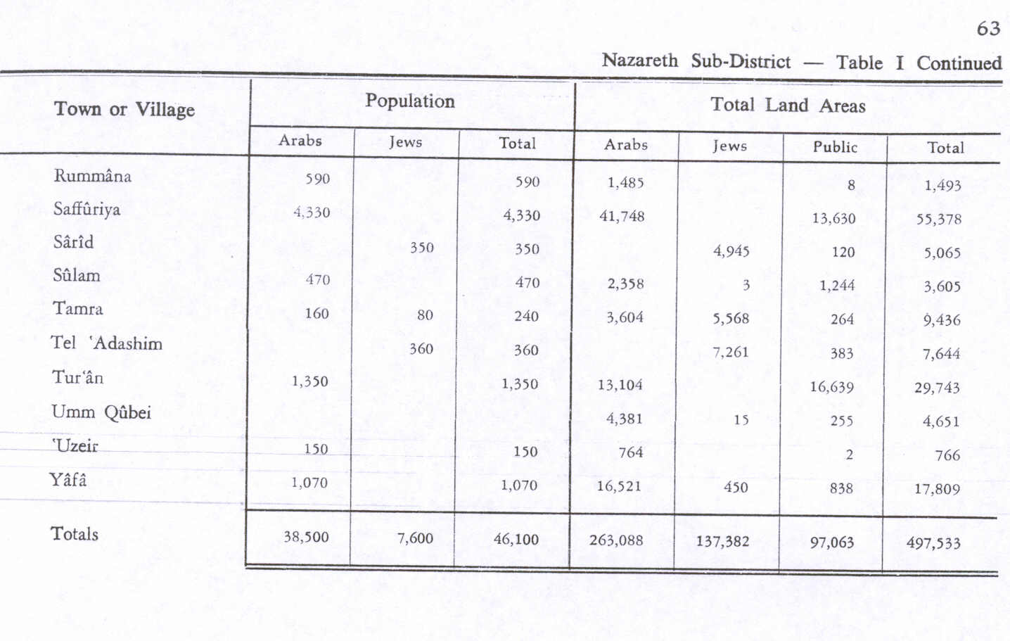
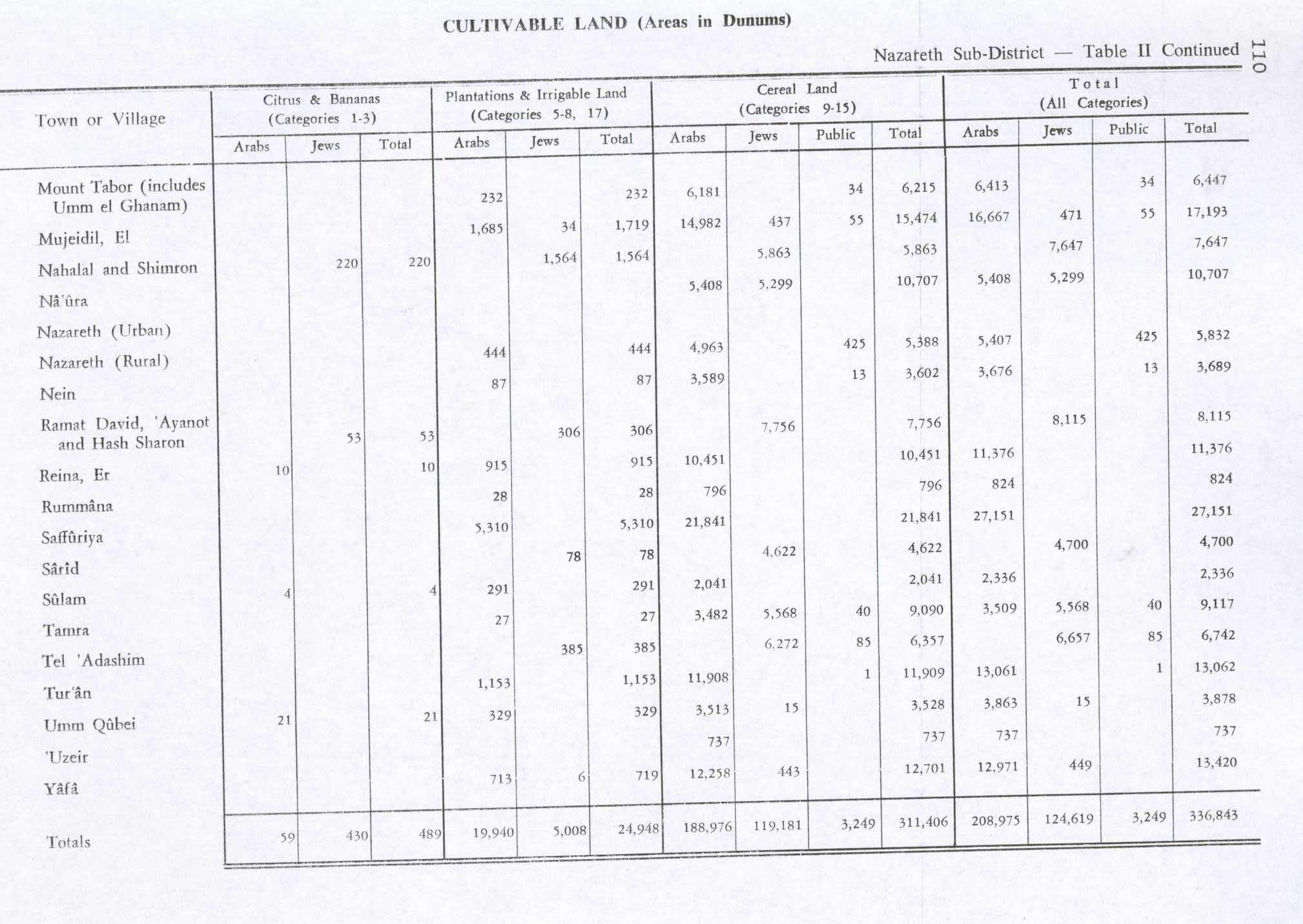
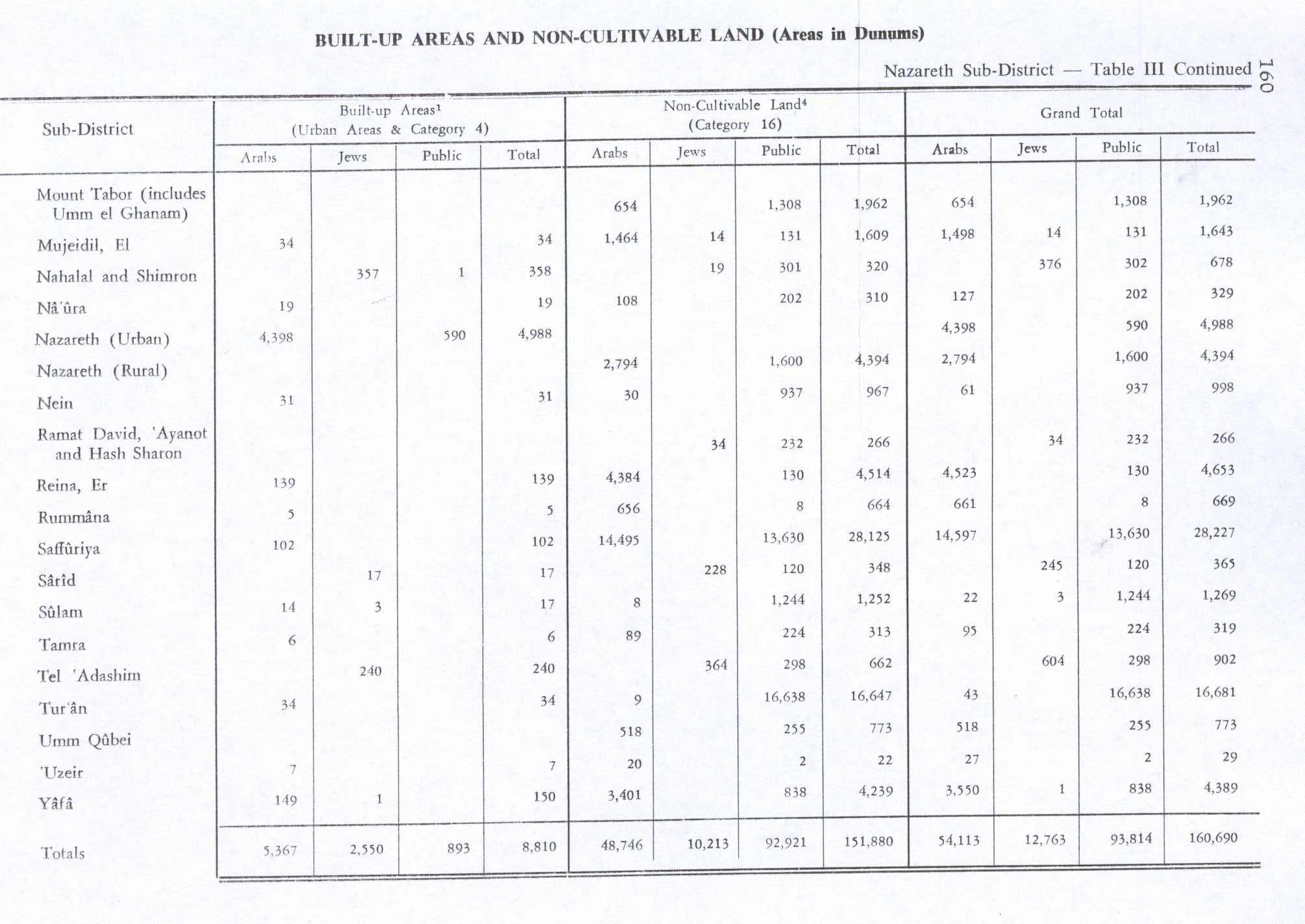
In 1945 the population was 590 while the total land area was 1,493 dunams, according to an official land and population survey.[14] Of this, 28 dunams were allocated for plantations and irrigable land, 796 for cereals,[15] while 5 dunams were classified as built-up areas.[16]
1948, and aftermath
In 1948, the village was captured by the Israeli army during Operation Dekel, 15–18 July.[17] It remained under martial law until 1966.
References
- ↑ Palmer, 1881, p. 133
- ↑ Population by settlement Central Bureau of Statistics
- ↑ Conder and Kitchener, 1881, SWP I, p. 414
- ↑ Rey, 1883, p. 444
- ↑ Conder, 1890, pp. 35 -6
- ↑ Hütteroth and Abdulfattah, 1977, p. 188
- ↑ Karmon, 1960, p. 166
- ↑ Robinson and Smith, 1856, p. 109 ff
- ↑ Guérin, 1880, pp. 365 ff
- ↑ Conder and Kitchener, 1881, SWP I, p. 363
- ↑ Barron, 1923, Table XI, p. 38
- ↑ Barron, 1923, Table XVI, p. 51
- ↑ Mills, 1932, p. 75
- ↑ Government of Palestine, Department of Statistics. Village Statistics, April, 1945. Quoted in Hadawi, 1970, p. 63
- ↑ Government of Palestine, Department of Statistics. Village Statistics, April, 1945. Quoted in Hadawi, 1970, p. 110
- ↑ Government of Palestine, Department of Statistics. Village Statistics, April, 1945. Quoted in Hadawi, 1970, p. 160
- ↑ Morris, Benny (1987) The birth of the Palestinian refugee problem, 1947-1949. Cambridge University Press. ISBN 0-521-33028-9. p.200.
Bibliography
| Wikimedia Commons has media related to Rumana. |
- Barron, J.B., ed. (1923). Palestine: Report and General Abstracts of the Census of 1922. Government of Palestine.
- Conder, C. R. (1890). "Norman Palestine". Quarterly statement - Palestine Exploration Fund 22: 29–37.
- Conder, Claude Reignier; Kitchener, H. H. (1881). The Survey of Western Palestine: Memoirs of the Topography, Orography, Hydrography, and Archaeology 1. London: Committee of the Palestine Exploration Fund.
- Guérin, Victor (1868). Description Géographique Historique et Archéologique de la Palestine (in French). 1: Judee, pt. 1. Paris: L'Imprimerie Nationale.
- Hadawi, Sami (1970). Village Statistics of 1945: A Classification of Land and Area ownership in Palestine. Palestine Liberation Organization Research Center.
- Hütteroth, Wolf-Dieter; Abdulfattah, Kamal (1977). Historical Geography of Palestine, Transjordan and Southern Syria in the Late 16th Century. Erlanger Geographische Arbeiten, Sonderband 5. Erlangen, Germany: Vorstand der Fränkischen Geographischen Gesellschaft. ISBN 3-920405-41-2.
- Karmon, Y. (1960). "An Analysis of Jacotin's Map of Palestine". Israel Exploration Journal 10 (3,4): 155–173; 244–253.
- Mills, E, ed. (1932). Census of Palestine 1931. Population of Villages, Towns and Administrative Areas. Jerusalem: Government of Palestine.
- Palmer, E. H. (1881). The Survey of Western Palestine: Arabic and English Name Lists Collected During the Survey by Lieutenants Conder and Kitchener, R. E. Transliterated and Explained by E.H. Palmer. Committee of the Palestine Exploration Fund.
- Rey, Emmanuel Guillaume (1883). Les colonies franques de Syrie aux XIIme et XIIIme siècles (in French). Paris: A. Picard.
- Robinson, Edward; Smith, Eli (1856). Later Biblical Researches in Palestine and adjacent regions: A Journal of Travels in the year 1852. London: John Murray.
- Stepansky, Yosef (2000): Rumana, Hadashot Arkheologiyot – Excavations and Surveys in Israel, No. 112.
- Velde, van de, Charles William Meredith (1854). Narrative of a journey through Syria and Palestine in 1851 and 1852 2. William Blackwood and son.(p. 404)
External links
- Welcome To Rummana
- Survey of Western Palestine, Map 6: IAA, Wikimedia commons
| ||||||