Ruisui, Hualien
| Ruisui Township 瑞穗鄉 | |
|---|---|
| Nickname(s): Mizuho (水尾,みずほ) | |
 | |
| Coordinates: 23°26′0″N 121°30′0″E / 23.43333°N 121.50000°ECoordinates: 23°26′0″N 121°30′0″E / 23.43333°N 121.50000°E | |
| Country |
|
| Region | Eastern Taiwan |
| Government | |
| • Type | Township |
| Area | |
| • Total | 135.5862 km2 (52.3501 sq mi) |
| Population (December 2014) | |
| • Total | 12,107 |
| Time zone | CST (UTC+8) |
| Post code | 978 |
| Subdivision | 11 Villages |
| Website | www.juisui.gov.tw (Chinese) |
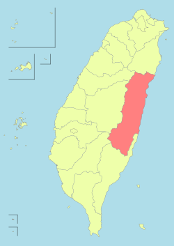
Ruisui Township (Chinese: 瑞穗鄉; pinyin: Ruìsuì Xiāng) is a rural township located in southern Hualien County, Taiwan, and has a population of 12,107 inhabitants and 11 villages. The Tropic of Cancer passes through here.
This township is an alluvial plain which located in the mid Huatung Valley between Central Mountain Range, Coastal Mountain Range and Wuhe Terrace. Rafting activity on the Xiuguluan River often starts from the Ruisui Bridge.
The climate is between tropical and subtropical momsoon with humid climate. The population is composed of Min Nan, Hakka, and Taiwanese aborigines, most of which is the Amis tribe. Agriculture and tourism are major industries.
History
During Qing rule, the headquarters of Taitung Prefecture was located in modern-day Ruisui, known then as Tsui-be,[1] or Tsui-boe[2] (Chinese: 水尾; Pe̍h-ōe-jī: Chúi-bóe).
Administrative divisions
- Ruisui Village
- Ruimei Village
- Ruiliang Village
- Ruixiang Village
- Ruibei Village
- Wuhe Village
- Hegang Village
- Jimei Village
- Fuyuan Village
- Fumin Village
- Fuxing Village[3]
Tourist attractions


- Ruisui Hotspring
- Honyeh Hotspring (Red Leaf Hotspring)
- The Tropic of Cancer Marker Park
- Wuhe Terrace Tea Farm
- Ruisui Rafting Tourist Center (Xiuguluan River Rafting)
- Ruisui Range
- Fuyuan Bao'an Temple
- Fuyuan Butterfly Village
- Maliyun Tribal Village
- Ruisui Qinglian Temple
- Saoba Stone Pillars[4]
Transportation
- TRA Ruisui and Fuyuan Station - Hualien-Taitung Line
- Provincial Highway No.9
- County Road No.193
See also
References
- ↑ Campbell, William (1915). Sketches from Formosa. London: Marshall Brothers. p. 278. OL 7051071M.
The eastern prefecture of TAI-TANG, made up of the two sub-prefectures of Pi-lam and Hoe-lian-kang, with head-quarters at the middle-eastern centre called Tsui-be.
- ↑ Campbell (1896), map.
- ↑ http://vote2014.nat.gov.tw/en/TV/nm709001000000000.html
- ↑ http://www.erv-nsa.gov.tw/user/Article.aspx?Lang=2&SNo=03000455
Bibliography
- Campbell, William (1896). "The island of Formosa: Its past and future". Scottish Geographical Magazine 12 (8): 385–399. doi:10.1080/00369229608732903.
External links
- Office of Ruisui Township (Chinese)
| |||||||||||||||||||||
| |||||||||||||||||||||||||||||||||||||||||||||||||||||||||||||||||||||||||||||||||||||

![[2]](#cite_note-FOOTNOTECampbell1896.5B.5B.3Ac.3AFile.3A1896_map_of_Taiwan.png.7Cmap.5D.5D-4)