Ruiru
| Ruiru | |
|---|---|
| Town | |
|
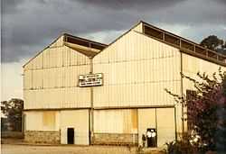
East African Power & Lighting building in Ruiru on the Nairobi-Thika highway, taken in about 1960 | |
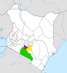
 Ruiru Location in Kenya | |
| Coordinates: 1°8′56″S 36°57′25″E / 1.14889°S 36.95694°ECoordinates: 1°8′56″S 36°57′25″E / 1.14889°S 36.95694°E | |
| Country |
|
| County | Kiambu County |
| Population (2009) | |
| • Total | 238,858[1] |
| Time zone | EAT (UTC+3) |
| Climate | Cwb |
Ruiru is a town in the Kiambu County in Kenya. Located within 3 kilometres (1.9 mi) of Nairobi's city boundary, Ruiru is a dormitory town for the nation's capital, and is connected by both rail and road. The town covers an area of 292 km2 (113 sq mi), and is surrounded by numerous coffee plantations.
As of 2009, Ruiru's population stood at 238,858,[1] the rapid population growth being a response to the shortage of available housing in Nairobi. The town has struggled to adapt to the influx of people.[2] Ruiru is also an industrial town with several major factories, including Devki Steel Mills, Spinners & Spinners Garment Factory and Ruiru Feeds. It is well served by banks and shopping malls and currently is enjoying a housing boom, as many coffee estates are converted into residential areas, including an upcoming multi-billion Tatu Estate. ICT businesses are also emerging, including SmartEdge PASHA center, a digital village by the KICT board where the community can buy computers and get free computer training.
This area was a sisal and coffee growing district with sisal on either side of the river to the right of the main road to Thika. As can be seen it is now a housing area. There used to be four main manager houses on the estate on the South side of the river. The area was given over to an African consortium to be developed into small holdings in the 1970s.
Sources
- Regional Development of Metropolitan Nairobi and the Ruiru Master Plan — Center for Sustainable Urban Development (archived from the Wayback Machine)
References
- ↑ 1.0 1.1 Ruiru fact sheet
- ↑ Kenya National Bureau of Statistics
External links
| |||||||||||||||||||||||||||||