Ruillé-le-Gravelais
| Ruillé-le-Gravelais | ||
|---|---|---|
|
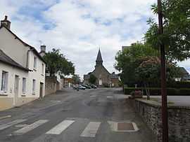
The church in Ruillé-le-Gravelais | ||
| ||
 Ruillé-le-Gravelais | ||
|
Location within Pays de la Loire region  Ruillé-le-Gravelais | ||
| Coordinates: 48°03′24″N 0°57′15″W / 48.0567°N 0.9542°WCoordinates: 48°03′24″N 0°57′15″W / 48.0567°N 0.9542°W | ||
| Country | France | |
| Region | Pays de la Loire | |
| Department | Mayenne | |
| Arrondissement | Laval | |
| Canton | Loiron | |
| Government | ||
| • Mayor (2008–2014) | Hervé Lemoine | |
| Area1 | 16.94 km2 (6.54 sq mi) | |
| Population (2006)2 | 826 | |
| • Density | 49/km2 (130/sq mi) | |
| INSEE/Postal code | 53194 / 53320 | |
| Elevation |
90–191 m (295–627 ft) (avg. 105 m or 344 ft) | |
|
1 French Land Register data, which excludes lakes, ponds, glaciers > 1 km² (0.386 sq mi or 247 acres) and river estuaries. 2 Population without double counting: residents of multiple communes (e.g., students and military personnel) only counted once. | ||

Ruillé-le-Gravelais is a commune in the Mayenne department in north-western France.
Geography
The Oudon River flows through the middle of the commune and forms part of its southern border.
See also
- Communes of Mayenne
| Wikimedia Commons has media related to Ruillé-le-Gravelais. |