Rue Rambuteau
 | |
| Length | 975 m (3,199 ft) |
|---|---|
| Width | 5.5 to 13 m (18 to 43 ft) |
| Arrondissement | 1st, 3rd, 4th |
| From | Rue des Archives |
| To | Rue Coquillière |
| Construction | |
| Completion | 5 March 1838 |
The Rue Rambuteau is a street in Paris named after the Count de Rambuteau who started the widening of the road prior to Haussmann's renovation of Paris.[1] Philosopher Henri Lefebvre lived on the street and observed from his window the rhythms of everyday life at the intersection located behind the Centre Georges Pompidou.[2]
Location
Rue Rambuteau is a street in central Paris that connects the neighborhood of Les Halles, in the 1st arrondissement, to the Marais district in the 4th arrondissement. It fronts the Forum of Les Halles and the north side of Centre Georges Pompidou, and marks the boundary between the 3rd and 4th arrondissements. It occupies a special place in the history of Paris, because it is the first street to pierce the medieval center, during the reign of Louis Philippe I, a few years before the great work of Baron Haussmann. Rue Rambuteau has a length of 975 metres (3,199 ft) and a width of 13 metres (43 ft).
History
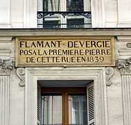
Rambuteau Street was created by order of King Louis Philippe I dated 5 March 1838. In 1839 the street was given the name of the prefect of the Seine department, Claude Philibert Barthelot, Count Rambuteau. The new street absorbed the Rue des Ménétriers, between Rue Beaubourg and Rue Saint-Martin; Rue de la Chanverrerie[lower-alpha 1] between Rue Saint-Denis and Rue Mondétour; and the Rue Traînée between Rue Montmartre et Rue du Jour.
The prefect Rambuteau, at the request of residents,[3] decided in 1834 to create a street 13 metres (43 ft) wide, an important dimension for the time. The center of Paris had hitherto kept its medieval urban fabric composed mainly of narrow streets where traffic was difficult and hygiene was poor. Taking office in 1833, a year after a major cholera epidemic, Rambuteau decided to implement the hygienist theories of the time by cutting a wide path through the center of Paris. A few years later, the prefect Haussmann would apply Rambuteau's principles on a much larger scale in boulevards such as the Boulevard de Sébastopol that crosses the Rue Rambuteau.

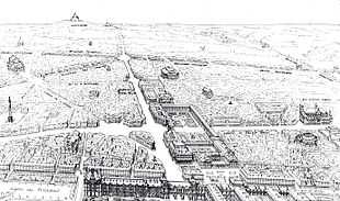
In 1904 the visionary urban planner Eugène Hénard presented a project for a new major east-west crossing of Paris.[4] The east-west artery, the new Avenue du Palais-Royal, would run along the route of the Rue Rambuteau, which would be expanded, through the Palais-Royal and into the Avenue de l'Opéra.[5] The avenue would pass through arches cut through the wings of the Palais Royal.[6] It would intersect an expanded north-south Rue de Richelieu in a roundabout, cutting into the west side of the Palais-Royal.[7] The entire project was discussed for several years, and in 1912 gave rise to great controversy within the Commission of Old Paris.[6] However, the proposal did not gain official support.[7]
Buildings
- In 1853 the building at number 34 was the headquarters of the publishing house of Charles Durand (1804-1863), the poet, singer and patron of goguettes.[8]
- The Centre Georges Pompidou
- The Church of St. Eustache .
- The Forum of Les Halles .
- At number 50, the MK2 Beaubourg.
Rue Rambuteau is served by the Rambuteau station at the Pompidou center and the Les Halles station at the Forum des Halles. The entrance to the latter station is inserted in the front of a building at number 230.
Gallery
-

-
-
MK2 Beaubourg
-

-

Corner of rue Rambuteau and rue des Archives
References
Notes
- ↑ The Rue de la Chanverrerie was called "rue de la Chanvrerie" by Victor Hugo in Les Misérables, the high place of L'idylle rue Plumet et l'épopée rue Saint-Denis part IV of his work
Citations
- ↑ Papayanis 2004, p. 126.
- ↑ Revol 2012.
- ↑ Chadych 2010.
- ↑ Flonneau 2003, p. 253.
- ↑ Nord 2005, p. 238.
- ↑ 6.0 6.1 Le Palais Royal: exposition 1988, p. 282.
- ↑ 7.0 7.1 Rykwert 2004, p. 100.
- ↑ Durand 1853.
Sources
| Wikimedia Commons has media related to Rue Rambuteau. |
- Chadych, Danielle (2010-10-14). Le Marais: Evolution d'un paysage urbain. Parigramme. ISBN 978-2-84096-683-8. Retrieved 2013-05-27.
- Durand, Charles (1853). "Notice sur la tour Saint-Jacques, depuis sa fondation jusqu'à nos jours,... : avec tous les évènements historiques qui s'y rattachent".
- Flonneau, Mathieu (2003). L'automobile à la conquête de Paris: Chroniques illustrées. Presses des Ponts. p. 113. ISBN 978-2-85978-373-0. Retrieved 2013-05-26.
- Le Palais Royal: exposition Musée Carnavalet, 9 mai-4 septembre 1988 (in French). Edition Paris-Musées. 1988. p. 282. ISBN 978-2-901414-30-8. Retrieved 2013-05-26.
- Nord, Philip G (2005). The Politics Of Resentment: Shopkeeper Protest In Nineteenth-century Paris. Transaction Publishers. ISBN 978-1-4128-3843-6. Retrieved 2013-05-25.
- Papayanis, Nicholas (2004-10-13). Planning Paris Before Haussmann. JHU Press. p. 126. ISBN 978-0-8018-7930-2. Retrieved 2013-05-27.
- Revol, Claire (6 April 2012). "Rue Rambuteau Today : Rhythmanalysis in Practice". Rhuthmos.
- Rykwert, Joseph (2004). The seduction of place: the history and future of the city. Oxford University Press. p. 99. ISBN 978-0-19-280554-6. Retrieved 2013-05-26.
Coordinates: 48°51′42″N 2°21′05″E / 48.861682°N 2.351447°E

