Royal Navy Cordite Factory, Holton Heath
The Royal Navy Cordite Factory, Holton Heath, (RNCF), was set up at Holton Heath, Dorset in World War I to manufacture cordite for the Royal Navy. It was reactivated in World War II to manufacture gun propellants for the Admiralty and its output was supplemented by the Royal Navy Propellant Factory, Caerwent. After the end of World War II, the explosive manufacturing areas of the site were closed down and some areas of the site reopened as an Admiralty Research Establishment. A major part of the explosives site became a nature reserve [1] in 1981. Other parts of the site were converted into an industrial estate; and some may be used for housing.
The Admiralty Research Establishment became part of Defence Research Agency (DRA) and DRA Holton Heath finally closed in the late 1990s. None of the site is now owned by the Ministry of Defence.
The site
A site was needed because Winston Churchill, the First Lord of the Admiralty, insisted that the Royal Navy had their own independent supply of Cordite. The Army was to be supplied with Cordite from the HM Factory, Gretna, at Gretna, Scotland, another remote location. Holton Heath was chosen in 1914 because of its remote location, away from centres of population, and its good transportation links, on a backwater of Poole Harbour, adjacent to the London and South Western Railway,and the A351 Wareham to Poole road.
During construction and during World War I, it was guarded by a detachment of armed Metropolitan Police. After World War I, the site was guarded by the Royal Marine Police; and later the Ministry of Defence Police. There were several scares and false alarms during construction, i.e. claims that various builder's and contractor's English or Irish employees were German spies or saboteurs. All these claims had to be investigated. In 1935, during the Re-armament Period, a new nitroglycerin plant was bought from Cologne, Germany, and installed by German technicians. It was necessary for the police to guard them, as they may otherwise have been attacked due to resentment about the rise in power of Nazi Germany and memories of World War I.[2]

The main site was bounded by the A351, Station Road and the London and South Western Railway. Holton Heath railway station was opened to serve the RNCF, which was linked to the railway by a siding which entered the site just east of the station. A few administration buildings were built on the other side of Station Road. A coal-fired water pumping house was also built away from the main site, at Corfe Mullen, to pump water from the River Stour.[3] Supplied with coal from its own railway siding on the Somerset and Dorset Railway, which passed nearby, it was linked to a 3.5 million gallon reservoir inside the RNCF by a 16-inch water main.[3]
A jetty, Rockley Jetty, was also constructed in Poole Harbour just outside the main site. It was used to transport Cordite by boat to Priddy's Hard, in Gosport.[3] The jetty was linked into the factory's railway system using standard gauge track. This private track ran parallel to the London and South Western Railway (LSWR) for some distance. It crossed over the top of the LSWR means of a bridge.
A feature-length documentary DVD entitled Cordite! The Story of the Royal Naval Cordite Factory, filmed and directed by John Hale of Wareham, Dorset, was released in 2012. It features the stories behind many of the buildings past and present mentioned in the paragraphs above, together with the experiences of some of the past employees of the RNCF. The DVD, which runs for 109 minutes, is introduced by John England and Dr Bob Dukes, both of whom latterly worked on the site.
World War I
To be added.
Chaim Weizmann and Acetone
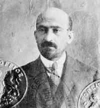
Production of Cordite required large volumes of the solvent Acetone and this was in short supply. At the time, acetone was manufactured by destructive distillation of wood. Chaim Weizmann had developed a process of bacterial fermentation, using Clostridium acetobutylicum, in 1912 but it did not appear to have any commercial value.
Chaim Weizmann was introduced to David Lloyd George, Minister of Munitions, and Winston Churchill in 1915 and was given facilities to develop the process. He used a laboratory at the Lister Institute in London and industrial plant at Nicholson's Gin Distillery in Bow (Three Mills) to perfect it.
A full scale acetone plant was set up at the RNCF using bacterial fermentation of Grain. By 1917 there was a shortage of grain so Horse Chestnuts were used as an alternative source of starch. Local school children were asked by the Ministry of Munitions to collect Horse Chestnuts; and six huge storage Storage silos were built to store the Horse Chestnuts. A larger bacterial fermentation plant was also set up in Canada as they had more Maize than the United Kingdom. After the end of World War I the bacterial fermentation plant was demolished but the silos were kept. In World War II the basements of RNCF silos were converted to Air-raid shelters; the silos being filled with earth to provide protection. They survived beyond the closure of the Holton Heath site (see below).
World War II
Note: The Royal Navy Cordite Factory, Holton Heath, like the Royal Navy Propellant Factory, Caerwent, were never part of the Ministry of Supply / Royal Ordnance Factory management chain; they were controlled by the Admiralty. However, they were functionally very similar to the Explosive ROFs.
Post-war use
After the end of World War II, propellant manufacture ceased at Holton Heath, although Caerwent continued to produce Cordite.
The camp was also used as the fictitious 'Sandford Army Camp' in the UK television series 'Bad Lads Army Extreme' in 2006.
Secrecy of the installation
The site is located at the centre of this 1946 O. S. map above and to the right of Holton Heath station, which was opened during the First World War to allow staff to reach the works. There is however no trace of the works, which occupied the space between the railway and the main road, on the map.
Accidents
On 10 September 1927 an explosion killed 3 men working in an acetone recovery building. Acetone, used as a solvent in the cordite manufacturing process, was piped in vapour form from stoves to the store where it would be recovered for re-use. It was accidentally ignited in the pipe, causing the explosion.[4]
In November 1929 an explosion at the factory killed 1 worker and seriously injured 3 others.
On 23 June 1931 an explosion occurred in a nitroglycerin preparation chamber, killing 10 and injuring 19. Three buildings were destroyed and a storage tank was ruptured, spilling sulphuric acid in to the area. The explosion, which occurred at 10.45 am, was heard 20 miles away and people working outdoors 2 miles away were knocked over by the blast wave. Houses situated on the main road approximately 1 mile from the blast suffered extensive damage.[5]
References
Notes
- ↑ http://www.english-nature.org.uk/special/nnr/nnr_details.asp?nnr_name=&C=0&Habitat=0&natural_area=&local_team=0&spotlight_reserve=0&X=&NNR_ID=90
- ↑ Bowditch, Chapter 7: The new NG Hill
- ↑ 3.0 3.1 3.2 Bowditch
- ↑ "CORDITE FACTORY EXPLOSION: Three Men Killed". The Manchester Guardian. 12 September 1927. p. 10.
- ↑ "EXPLOSION IN A NAVAL FACTORY: 10 Men Blown to Pieces". The Manchester Guardian. 24 June 1931. p. 9.
Bibliography
- Bowditch, M.R. and Hayward, L (1996). A Pictorial Record of the Royal Naval Cordite Factory, Holton Heath. Wareham: Finial Publishing. ISBN 1-900467-01-1
- Pomeroy, Colin A., (1995). Military Dorset Today: Second World War scenes and settings that can still be seen 50 years on. Peterborough: Silver Link Publishing Ltd. ISBN 1-85794-077-6
- Sutton, Michael, (2002). Moulder of molecules: maker of a Nation, Chemistry in Britain, 38, pp 34 – 36. (December 2002).
External links
| Wikimedia Commons has media related to Royal Navy Cordite Factory, Holton Heath. |