Royal Canal
| Royal Canal An Chanáil Ríoga | |
|---|---|
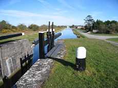
|
Royal Canal from D'Arcy's bridge, Co. Westmeath | |
| Specifications | |
| Length | 90 miles (140 km) |
| Status | Open |
| Navigation authority | Waterways Ireland |
| History | |
| Construction began | 1790 |
| Date completed | 1817 |
| Date restored | 2010 |
| Geography | |
| Start point | Cloondara |
| End point | Spencer Dock, Dublin |
| Connects to | River Shannon |


The Royal Canal (Irish: An Chanáil Ríoga) is a canal originally built for freight and passenger transportation from the River Liffey in Dublin to Longford in Ireland. The canal fell into disrepair in the late 20th century, but much of the canal has since been restored for navigation. The length of the canal to the River Shannon was reopened on 1 October 2010, but the final spur branch of the canal to Longford Town remains closed.
History
Work commenced in 1790 and lasted 27 years before finally reaching the Shannon in 1817, at a total cost of £1,421,954.[1] The canal passes through Maynooth, Kilcock, Enfield, Mullingar and Ballymahon has a spur to Longford. The total length of the main navigation is 145 kilometres (90 mi), and the system has 46 locks. There is one main feeder (from Lough Owel), which enters the canal at Mullingar.
At the Dublin end, the canal reaches the Liffey through a wide sequence of dock and locks at Spencer Dock, with a final sea lock to manage access to the river and sea.


In 1843, while walking with his wife along the Royal Canal, Sir William Rowan Hamilton realised the formula for quaternions and carved his initial thoughts into a stone on the Brougham Bridge over the canal.
Transport links
The Dublin – Mullingar railway line was built alongside the canal for much of its length. The meandering route of the canal resulted in many speed-limiting curves on the railway. The canal was bought by the Midland Great Western Railway to provide a route to the West of Ireland, the original plan being to close the canal and build the railway along its bed.
The canal travels across one of the major junctions on the M50/N3 in a specially constructed aqueduct.
Present day
By the 1970s, the canal was falling into total disrepair and became a dumping ground for old cars and rubbish. Proposals that the inner Dublin part of the canal be converted to a motorway led to the local community forming an action group The Royal Canal Amenity Group (RCAG), whose goal was to save and restore the canal. Today Waterways Ireland is responsible for the canal, and it was under their stewardship in association with The Royal Canal Amenity Group that the Royal Canal was officially reopened from Dublin to the Shannon, on 2 October 2010.[2] Access points currently exist near Leixlip and at Maynooth, Enfield, Thomastown, Mullingar, Ballinea Bridge and Ballynacargy.
In 2006 a commemoration marker was erected at Piper's Boreen, Mullingar, to mark the 200 years since the canal reached Mullingar in 1806.
Royal Canal Way
The Royal Canal Way is a 144-kilometre (89-mile) long-distance trail that follows the towpath of the canal from Ashtown, Dublin to Cloondara, County Longford.[3] It is typically completed in three days.[3] It is designated as a National Waymarked Trail by the National Trails Office of the Irish Sports Council and is managed by Waterways Ireland.[3] The Royal Canal Way connects with the Westmeath Way west of Mullingar, and will eventually form the eastern end of the Dublin-Galway Greenway.[4][5][6]
The Auld Triangle
The Royal Canal was immortalised in verse by Brendan Behan's brother in The Auld Triangle. A monument featuring Behan sitting on a bench was erected on the canal bank at Binn's Bridge in Drumcondra in 2004.
- And the auld triangle went jingle jangle,
- All along the banks of the Royal Canal.
The other major canal in Ireland is the Grand Canal from Dublin's southside through the Midlands to the River Shannon.
The Broadstone Line
In the 19th century Broadstone was one of the most well known areas of Dublin, however very few people even know where it is today. From 1817 this area was home to one of the major transport hubs in 19th century Dublin, containing a major railway station and a canal harbour, linking to the Grand Canal, crossing the North Circular Road, and going past the Mountjoy prison. Along the way there were 3 dry docks. This area rose and fell in prominence among Dubliners as new forms of transport came and went.
The aqueduct and canal that once linked the site to the Royal canal are gone almost without a trace and what was a glorious Neo-Egyptian railway station is now a bus depot and garage. The canal was filled in at around 1927, converted into Blessington Park, and Phibsborough Library was built on top of it.
See also
- List of bridges over the Royal Canal in Greater Dublin
- Canals of Ireland
- Rivers of Ireland
- Transport in Ireland
References
- ↑
- ↑ Ellis, Fiona (2 October 2010). "Crowds gather to push boat out for reopening of restored Royal Canal". Irish Independent. Retrieved 2 October 2010.
- ↑ 3.0 3.1 3.2 "Royal Canal Way". IrishTrails. Irish Sports Council. Retrieved 8 August 2011.
- ↑ "Westmeath Way: Map 3 Ladestown to Mullingar" (pdf). IrishTrails. Irish Sports Council. Retrieved 8 August 2011.
- ↑ "€10m More For Cycleways". HospitailityIreland.com. 15 May 2014. Retrieved 6 August 2014.
- ↑ Melia, Paul (27 June 2014). "Wheels in motion for 280km coast-to-coast cycle route". Irish Independent (Dublin).
External links
| Wikimedia Commons has media related to Royal Canal. |
- IWAI – Guide to the Royal Canal of Ireland
- Bond Bridge, Maynooth
- The Royal Canal(Longford Branch)
- Royal Canal Amenity Group
- Royal Canal Walk
- Broadstone station history
- Broadstone line walk
| |||||||||||||||||||||||||

| ||||||||||||||||||||||||||||||||||||||||||||||||||||||||||||||||||||||||||||||
.jpg)
| ||||||||||||||||||||||||||