Roxboro, Quebec
| Roxboro | |
|---|---|
| Neighbourhood | |
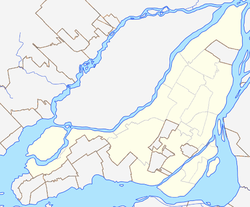
 Roxboro Location of Roxboro in Montreal | |
| Coordinates: 45°30′31″N 73°49′0″W / 45.50861°N 73.81667°WCoordinates: 45°30′31″N 73°49′0″W / 45.50861°N 73.81667°W | |
| Country |
|
| Province |
|
| City |
|
| Borough | Pierrefonds-Roxboro |
| Area[1] | |
| • Land | 2.22 km2 (0.86 sq mi) |
| Population (2006)[1] | |
| • Total | 5,948 |
| • Density | 2,682.3/km2 (6,947/sq mi) |
| • Change (2001-2006) |
|
| • Dwellings (2006) | 2,162 |
| Time zone | Eastern (EST) (UTC-5) |
| • Summer (DST) | EDT (UTC-4) |
| Postal code span | H8Y |
| Area code(s) | (514) and (438) |
Roxboro was a town on the Island of Montreal. It was founded in 1914,[2] and ceased to exist on January 1, 2002 with a forced merger with Montreal. The town was located along the Rivière des Prairies. Its population, at that time, was 6,000.
In 2004 there was a chance at demerging from Montreal but the requirements were not met. Voting results were: Registered to vote 4 487: Yes 1,497: No 732: Total of Yes and No votes 2,248.[3]
-
Roxboro sign on 1st Avenue North
-
Pumping Station
-
Plaque
History
Since the Town's founding in 1914, there have been six mayors.
- March 19, 1914 John Rowley
- March 5, 1936 Geo. H. Whitehead
- June 4, 1946 Roland Bigras
- July 11, 1958 René Labelle
- November 2, 1964 William G. Boll
- November 4, 1990 Ovide T. Baciu
The city of Montreal had tried for years to merge Roxboro and other municipalities. [4] [5]
The area north of the train tracks was subject to many floods.[6][7][8][9] Pumping stations were built to help stop the flooding.
On January 1, 2002, the formerly independent town was forcibly merged with Dollard-des-Ormeaux to become a borough in the new city of Montreal. When offered the chance to "de-merge" on June 20, 2004, residents of the former town voted to do so by 67%. However because the province required 35% turnout for the result to be valid, the town was merged regardless of the wishes of those who voted. Residents of the former city of Pierrefonds, which adjoined the former town of Roxboro, chose to stay in the new city and joined with Roxboro to form the borough of Pierrefonds-Roxboro. The new borough was formally created on January 1, 2006. Roxboro's former borough partner, Dollard-des-Ormeaux, chose to regain their independence and de-merged at that time.
Roxboro Island
In 1974 the town of Roxboro purchased the island for $55,000.[10] Archives de Montréal has an aerial photo of the island from the year 1947.[11] It is one of islands in the Hochelaga Archipelago. The island has a bridge, lighting for night and garbage disposal.
Roxboro Woods
There is a section of land named "Boisé de Roxboro" designated 2001-08-22 as a protected woods. The Quebec government does not act to protect the woods and as a result the area of land has significantly shrunk and continues to grow smaller from development.[12]
References
- ↑ 1.0 1.1 "Community Profile - Roxboro". Canada 2006 Census. Statistics Canada. 2010-12-06. Retrieved 22 September 2012.
- ↑ D. W. Spencer, ed. (1964). Roxboro Québec: 1914–1964. 50th Anniversary Celebration Committee.
- ↑ http://www.electionsquebec.qc.ca/english/tables/result-referendum-2004.php
- ↑ "M.U.C. subcommittee recommends merger". The North Shore News. April 5, 1973.
- ↑ "Roxboro will oppose merger". The North Shore News. April 5, 1973.
- ↑ "Roxboro Resident, Mayor Differ On Flooding Cause". The Montreal Gazette. Dec 27, 1957.
- ↑ "Roxboro's Mayor Boll clarifies flood problem". The North Shore News. April 5, 1973.
- ↑ "Flood control up to government". The North Shore News. August 2, 1973.
- ↑ "Roxboro racing to bolster spring flood defenses". The North Shore News. March 10, 1977.
- ↑ The North Shore News, Page 3 , August 22, 1974. "Roxboro buys island"
- ↑ Archives de Montréal
- ↑ http://www.toponymie.gouv.qc.ca/ct/ToposWeb/fiche.aspx?no_seq=371489
External links
- History of Roxboro, with an emphasis on the local Mary Queen of Peace church. Note that the French version of this page contains significantly more information than the English page.
- From collectionscanada.gc.ca Gordon & Gotch's 1924 Map of the Island of Montreal. Town of Roxboro is named on this map.


