Route 1 (Iceland)
| |
|---|---|
| Þjóðvegur 1 | |
|
| |
| Route information | |
| Length: | 1,332 km (828 mi) |
| Highway system | |
| National Roads in Iceland | |

.png)
Route 1 or the Ring Road (Icelandic: Þjóðvegur 1 or Hringvegur) is a national road in Iceland that runs around the island and connects most of the inhabited parts of the country. The total length of the road is 1,332 kilometres (828 mi). Some of the most popular tourist attractions in Iceland, such as the waterfalls Seljalandsfoss and Skógafoss, and Jökulsárlón glacier lagoon, are also on or near the Ring Road.[1]
The ring was completed in 1974, coinciding with the 1100th anniversary of the country's settlement[2] when the longest bridge in Iceland,[3] crossing the Skeiðará river in the southeast, was opened.
Characteristics
For almost all its length, the road is two lanes wide: one lane going in each direction. Where it passes through larger towns, the number of lanes may be increased, as also in the Hvalfjörður Tunnel. Many smaller bridges are single lane, especially in eastern Iceland, and constructed of wood and/or steel. The road is paved with asphalt for most of its length, but there are still stretches in eastern Iceland with an unpaved gravel surface. The Iceland Road Administration, Vegagerðin, oversees the maintenance and building of both main roads and minor roads.
Although paved, some portions of the road are still the original 1940s country roads, and contain hazards such as blind curves and blind summits, single lane bridges, and narrow passes. In winter, icy roads and sheer winds, 15 m/s for cars with trailers, 25m/s for cars without trailers, can make travel hazardous, as elsewhere in Iceland. Currently, 32 km out of the 1,332 km are unpaved.[4]
The maximum speed on most of the road is 90 kilometres per hour (56 mph), and 80 kilometres per hour (50 mph) on gravel.
Driving in winter
Almost all of Route 1 has winter service, mainly snow removal, but some parts are not kept open in the winter: most notably Breiðdalsheiði, between Breiðdalsvík and Egilsstaðir in the east; although it is kept open in spring, summer and autumn.[5]
Instead, travelers use the somewhat sinuous coastal route via Reyðarfjörður using Routes 96 and 92 to travel between these places. This is also an option in the summer, since Route 1 between these places is only 10 kilometres (6.2 mi) shorter than 92 and 96, but the latter is paved the whole way.[6]
Natural hazards
Route 1 crosses a few glacial outwash plains, such as Skeiðarársandur, which make road construction difficult. In addition, the Skeiðarársandur plain is subject to frequent glacial outburst floods during or after Grímsvötn eruptions. Bridges and other stretches of road over the plains have had to be rebuilt as a result.
Traffic
Traffic on the road varies considerably between locations: in and near Reykjavík it is around 5,000–10,000 vehicles per day, but the stretches farthest away from larger towns see fewer than 100 vehicles per day on average.
The Ring Road is popular with tourists since it covers most of the country and many sights of interest are not far from it. It has been an especially popular tour with Icelandic families on summer vacation, but in recent years the route is becoming more popular with foreigners who either rent a car or bring their own on the ferry to Seyðisfjörður.
Sections
The route goes by many names depending on location. The following table shows road names (excluding tunnels) in a clockwise direction from Reykjavík.


| Name | Location |
|---|---|
| Vesturlandsvegur | Eastern Reykjavík to Borgarnes |
| Borgarbraut | Borgarnes |
| Hringvegur | Borgarnes to northern Akureyri |
| Hörgárbraut | Akureyri |
| Glerárgata | Akureyri |
| Drottningarbraut (partial) | Akureyri |
| Hringvegur | Southern Akureyri to the turning for Höfn |
| Suðurlandsvegur | Höfn to Hella |
| Suðurlandsbraut | From Hella to Selfoss |
| Austurvegur | Selfoss |
| Suðurlandsvegur | From Selfoss to eastern Reykjavík |
Major links
Route 1 includes a number of bridges and a few tunnels. The most notable are:
- Hvalfjörður Tunnel
- Almannaskarð Tunnel
- Vaðlaheiði Tunnel (planned)
List of cities and towns on Route 1
Travelling clockwise (initially northward) from Reykjavík, the following communities and settlements are located on Route 1.
- Reykjavík
- Mosfellsbær
- Borgarnes
- Bifröst
- Blönduós
- Akureyri
- Reykjahlíð
- Egilsstaðir
- Breiðdalsvík
- Djúpivogur
- Höfn
- Kirkjubæjarklaustur
- Vík í Mýrdal (Vík)
- Skógar
- Hvolsvöllur
- Hella
- Selfoss
- Hveragerði
Gallery
-

Road sign
-

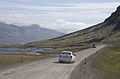
A typical stretch of Route 1, in Borgarfjörður
-

Road conditions are monitored in real time by a system of weather stations and webcams, such as this station at Vatnsskarð pass in north Iceland.
-

An icy stretch of Route 1 between Vík í Mýrdal and Höfn
-

Distance sign (southbound) near Egilsstaðir
-

Bridge crossing
-
Unpaved stretch between Egilsstaðir and Höfn

References
- ↑ "Best Attractions by the Ring Road of Iceland". Guide to Iceland.
- ↑ "Iceland: Milestones in Icelandic History". Iceland.vefur.is. Retrieved 2010-04-17.
- ↑ http://www.vegagerdin.is/vefur2.nsf/Files/Vegakerfid_english/$file/ATTRJY5V.pdf
- ↑ "Vegalengdir (Distances between places)" (in Icelandic). Icelandic Road Administration. Retrieved 12 February 2014.
- ↑ "Mokstursdagar" (in Icelandic). Icelandic Road Administration. Retrieved 12 February 2014.
- ↑ "Brottfararstaður Egilsstaðir" (in Icelandic). Icelandic Road Administration. Retrieved 12 February 2014.
Distances from Egilsstaðir, look up Breiðdalsvík
External links
- Gateway to Iceland
- Official Icelandic Road Administration
- Driving in Iceland
- Photos from Iceland Ring Road
- Iceland’s Ring Road: The Ultimate Road Trip
- Iceland Meteorology Bureau
- Umferðarstofa - Road Traffic Directorate
-
 Wikimedia Atlas of Iceland
| Wikimedia Commons has media related to Hringvegur. |