Route 1 (Hong Kong)
| ||||
|---|---|---|---|---|
|
Route 1 coloured red | ||||
| Route information | ||||
| Length: | 20.7 km (12.9 mi) | |||
| Existed: | 1966 (Princess Margaret Road) – present | |||
| Major junctions | ||||
| South end: | Aberdeen Praya Road, Aberdeen | |||
|
Sha Lek Highway, Sha Tin Wai | ||||
| North end: |
| |||
| Location | ||||
| Districts: | Southern, Central and Western, Wan Chai, Yau Tsim Mong, Kowloon City, Wong Tai Sin, Sha Tin | |||
| Highway system | ||||
|
Hong Kong Strategic Route and Exit Number System
| ||||

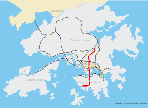
Route 1 (Chinese: 一號幹線) is a major artery in Hong Kong that runs in a generally north-south direction, connecting Aberdeen with Shatin.
The route is heavily congested, notably on the Canal Road viaduct that links the Aberdeen Tunnel with the Cross-Harbour Tunnel in Causeway Bay.[1] Route 1 continues to serve as the most direct route from the north shore of Hong Kong Island to the Southern District. The road travels across the harbour and runs through the middle of Kowloon and continues heading north into the New Territories.
History
Route 1 was established in January 2004 when the third generation of route numbers came into use, replacing the old system which had been used since 1974.
Route
The route begins in the south at Aberdeen Praya Road which continues as Wong Chuk Hang Road until reaching the Aberdeen Tunnel. The traffic runs on the Canal Road viaduct after exiting the tunnel in Happy Valley. The viaduct descends to the ground level passed the intersection at Gloucester Road for Route 4.
Traffic then crosses the Cross-Harbour Tunnel into Kowloon and keeps heading north along Princess Margaret Road and Waterloo Road. The stretch of Waterloo Road between Hereford Road and Lancashire Road in Kowloon Tong is the only section of the route that is not controlled access. Traffic then climbs a steep incline to reach the Lion Rock Tunnel. At the end of the tunnel, the road skirts the border of Tai Wai. Traffic has an option to merge to Route 9 in Shatin or branch off onto Route 2 for Ma On Shan.[2]
Exits and interchanges
| District | Location | km[n 1] | Exit | Destinations[5] | Notes | ||
|---|---|---|---|---|---|---|---|
| Aberdeen Praya Road | |||||||
| Southern | Wong Chuk Hang | 0.0 | Aberdeen Praya Road - Aberdeen | Southern terminus | |||
| 0.1 | 1 | Ap Lei Chau Bridge Road - Ap Lei Chau | Southbound exit and northbound entrance from and to Wong Chuk Hang Road respectively | ||||
| Wong Chuk Hang Road | |||||||
| Southern | Wong Chuk Hang | 0.2 | 1A | Heung Yip Road | Southbound exit and entrance only | ||
| 0.7 | 2 | Nam Long Shan Road - Wong Chuk Hang | |||||
| 1.2 | 3 | Ocean Park Road - Ocean Park, Nam Long Shan | |||||
| Aberdeen Tunnel | |||||||
| Southern | Wong Chuk Hang | 1.6 | 4 | Wong Chuk Hang Road / Nam Fung Road - Shouson Hill, Repulse Bay, Stanley; Wong Nai Chung Gap | Southbound exit and northbound entrance limited to Wong Chuk Hang Road | ||
| Wan Chai | Happy Valley | 2.3– 4.2 |
|||||
| Canal Road Flyover | |||||||
| Wan Chai | Happy Valley | 4.7 | 5 | Queen's Road East / Morrison Hill Road / Wong Nai Chung Road - Wan Chai; Causeway Bay; Happy Valley | Northbound exit and southbound entrance limited to Queen's Road East and Morrison Hill Road; southbound exit and northbound entrance limited to Queen's Road East and Wong Nai Chung Road | ||
| Causeway Bay | 5.3 | 5A | Leighton Road / Canal Road East - Causeway Bay | Southbound exit and northbound entrance only | |||
| Cross-Harbour Tunnel | |||||||
| Wan Chai | Causeway Bay | 5.6 | 6 | ||||
| Yau Tsim Mong | Victoria Harbour | 6.0– 7.9 |
|||||
| Hong Chong Road | |||||||
| Yau Tsim Mong | Hung Hom | 8.3 | 6A | Salisbury Road - Tsim Sha Tsui | Southbound exit and northbound entrance only | ||
| 8.4 | 6B | Railway Approach - Hung Hom Station | Southbound exit only | ||||
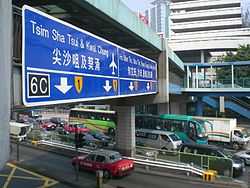
| 8.5 | 6C | Northbound exit and southbound entrance only | |||||
| 8.6 | 6D | Northbound exit and southbound entrance only | |||||
| 9.0 | 7A | Princess Margaret Road - Tsim Sha Tsui | Southbound exit and northbound entrance only | ||||
| 9.0 | 7B | Princess Margaret Road Link - Hung Hom Bay | Southbound exit and northbound entrance only | ||||
| Princess Margaret Road | |||||||
| Yau Tsim Mong | Hung Hom | 9.3 | 7C | Wylie Road | Northbound exit and entrance only | ||
| Kowloon City | Ho Man Tin | 9.4 | 7D | Chi Man Street | Southbound exit and entrance only | ||
| 9.7 | 7E | Chung Man Street - Ho Man Tin | Southbound exit and entrance only | ||||
| 10.1 | 8 | Pui Ching Road / Fat Kwong Street - Yau Ma Tei, Mong Kok; Ho Man Tin, Hung Hom | |||||
| Waterloo Road | |||||||
| Kowloon City | Mong Kok | 10.7 | 8A | Argyle Street - Mong Kok | No northbound exit | ||
| 11.2 | 8B | Prince Edward Road West - Mong Kok | Southbound exit and entrance only; entrance from Boundary Street | ||||
| 11.4 | 8C | Boundary Street - Kowloon City | Southbound exit and northbound entrance only | ||||
| 11.4 | 8D | Flint Road | Southbound exit only | ||||
| Kowloon Tong | 11.5 | 9 | Essex Crescent | Northbound exit only | |||
| 11.8 | 9A | Durham Road | No entrance | ||||
| 11.9 | 9C | Hereford Road | No northbound entrance | ||||
| 12.0 | 9E | Norfolk Road | Northbound exit only | ||||
| 12.2 | 9F | Junction Road / Suffolk Road / Dorset Crescent - Kowloon Tong, Lok Fu | Northbound exit and southbound entrance only; entrance from Junction Road only | ||||
| 12.9 | 9G | Cornwall Road - Tai Wo Ping, Kwai Chung | Southbound exit and northbound entrance only | ||||
| Lion Rock Tunnel Road | |||||||
| Kowloon City | Kowloon Tong | 13.4 | 10A | Southbound exit and northbound entrance only | |||
| 13.5 | 10B | Southbound exit and northbound entrance only | |||||
| Sha Tin | Lion Rock | 13.6– 15.0 |
|||||
| Hin Tin | 16.3 | 11 | Hung Mui Kuk Road - Tai Wai | ||||
| Sha Tin | Sha Tin Wai | 17.4 | 11A | Lion Rock Tunnel Road - Tsuen Wan, Sha Tin Central | Northbound exit and southbound entrance only | ||
| 18.3 | 11B | Northbound exit and southbound entrance only | |||||
| Yuen Chau Kok | 18.8 | 12 | Sha Tin Wai Road - Sha Tin Wai, Yuen Chau Kok, Kowloon East | ||||
| 19.5 | 12A | Fo Tan Road / Tai Chung Kiu Road - Fo Tan, Shek Mun | Northbound exit and southbound entrance only | ||||
| Fo Tan | 20.4 | 12B | Fo Tan Road - Sha Tin Central | Southbound exit and northbound entrance only | |||
| 21.1 | 12C | Yuen Wo Road - Penfold Park | Northbound exit and southbound entrance only | ||||
| 21.1 | Northern terminus | ||||||
1.000 mi = 1.609 km; 1.000 km = 0.621 mi
| |||||||
Notes
References
- ↑ "LCQ4: Traffic congestion along the link roads to the Aberdeen Tunnel". Information Services Department. Retrieved 17 November 2014.
- ↑ "Route Diagram - Route 1". Transport Department. Retrieved 10 January 2014.
- ↑ "Open Source Routing Machine". Retrieved 10 January 2014.
- ↑ "Google Maps Street View". Google. Retrieved 10 January 2014.
- ↑ "Route Diagram - Route 1". Transport Department of the Government of Hong Kong. Retrieved 10 January 2014.
| ||||||||||