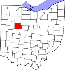
Roundhead, Ohio


Roundhead is an unincorporated community in southeastern Roundhead Township, Hardin County, Ohio, United States. Although it is unincorporated, it has a post office, with the ZIP code of 43346.[1] Located at an altitude of 1,004 feet (306 m),[2] it sits at the intersection of State Routes 117, 235, and 385, 2¾ mile (4½ km) north of the northeast corner of Indian Lake and 13 miles (24 km) southwest of the city of Kenton,[3] the county seat of Hardin County.[4] Despite Roundhead's proximity to Indian Lake and the Great Miami River, which flows out of it to the Ohio River at Cincinnati,[5] the community is drained by the headwaters of the Scioto River, which meets the Ohio River at Portsmouth.[6]
History

Founded in 1832, Roundhead is the oldest white community in Hardin County. During its history, it has also been referred to as "Round Head," "Round Heads," "Round Headstown," and "Roundheads Town."[2]
Roundhead is named for the great Wyandot chief Roundhead. The Wyandots, led by Chief Roundhead, had a prominent village on the banks of the Scioto in the location of present-day Roundhead. Chief Roundhead was an important ally of Tecumseh, and as Tecumseh's "enforcer" was helpful in "persuading" various Indian tribes to unite under Tecumseh and fight against aggression by the white man. Chief Roundhead signed the Treaty of Greenville as leader of the Wyandots.
An archaeological site, the Zimmerman Kame, is located in the Roundhead vicinity; it is listed on the National Register of Historic Places.[7]
Community
Besides its post office (established on 21 August 1876),[8] the community includes an elementary school,[9] a volunteer fire department,[10] and two cemeteries.[11][12]
References
| Wikimedia Commons has media related to Roundhead, Ohio. |
- ↑ Zip Code Lookup
- ↑ 2.0 2.1 U.S. Geological Survey Geographic Names Information System: Roundhead, Ohio
- ↑ DeLorme. Ohio Atlas & Gazetteer. 7th ed. Yarmouth: DeLorme, 2004, p. 46. ISBN 0-89933-281-1.
- ↑ "Find a County". National Association of Counties. Retrieved 2011-06-07.
- ↑ DeLorme. Ohio Atlas & Gazetteer. 7th ed. Yarmouth: DeLorme, 2004, pp. 56, 74. ISBN 0-89933-281-1.
- ↑ DeLorme. Ohio Atlas & Gazetteer. 7th ed. Yarmouth: DeLorme, 2004, p. 85. ISBN 0-89933-281-1.
- ↑ "National Register Information System". National Register of Historic Places. National Park Service. 2009-03-13.
- ↑ U.S. Geological Survey Geographic Names Information System: Roundhead Post Office
- ↑ U.S. Geological Survey Geographic Names Information System: Roundhead Elementary School
- ↑ U.S. Geological Survey Geographic Names Information System: Roundhead Volunteer Fire Department
- ↑ U.S. Geological Survey Geographic Names Information System: Old Roundhead Cemetery
- ↑ U.S. Geological Survey Geographic Names Information System: New Roundhead Cemetery
| |||||||||||||||||||||||||||||||||
Coordinates: 40°33′34″N 83°50′07″W / 40.55944°N 83.83528°W
