Round Mountain (Northern Tablelands)
| Round Mountain | |
|---|---|
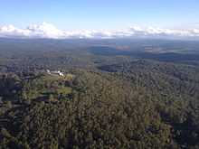
 Radar station, Round Mountain (click to enlarge) | |
| Elevation | 1,586 m (5,203 ft) |
| Location | |
| Location | New South Wales, Australia |
| Range | Snowy Range (Northern New South Wales) |
| Coordinates | 30°26′17″S 152°14′24″E / 30.438°S 152.240°ECoordinates: 30°26′17″S 152°14′24″E / 30.438°S 152.240°E |
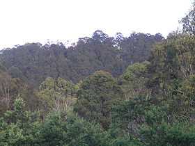
Round Mountain is the highest peak on the Northern Tablelands of the New England region in New South Wales, Australia.
Round Mountain is located in Cathedral Rock National Park about 72 kilometres (45 mi) east of Armidale, New South Wales and 63 km west of Dorrigo, New South Wales. It is the highest peak of the Snowy Range, a spur of the Great Dividing Range which forms part of the eastern escarpment of the Northern Tablelands. Note that this Snowy Range is not to be confused with the better-known one in the far south of New South Wales.
Round Mountain is 1,586 metres[1] above sea level. It is located about 10 km north west of the better known Point Lookout, in New England National Park, which is almost as tall and has a better view. It is located a few kilometres west of the small settlement of Ebor.
The northern slopes of Round Mountain are drained by the Guy Fawkes River which flows over the Ebor Falls and eventually into the Clarence River. The south slopes of Round Mountain are drained by the Styx River which flows to the Macleay River and the Oaky River which drains into the Chandler River.
A radar air navigation station, for the control and guidance of aircraft, is located on the summit of Round Mountain.
See also
References
- ↑ National Parks & Wildlife Service, "Cathedral Rock National Park", 2008