Rotorua
| Rotorua Te Rotorua-nui-a-Kahumatamomoeu (Māori) | |
|---|---|
| Main urban area | |
 | |
| Nickname(s): Sulphur City,[1] Roto-Vegas [2] | |
 Rotorua | |
| Coordinates: 38°08′16″S 176°15′05″E / 38.13778°S 176.25139°ECoordinates: 38°08′16″S 176°15′05″E / 38.13778°S 176.25139°E | |
| Country |
|
| Region | Bay of Plenty |
| Territorial authority | Rotorua District |
| Settled | pre-European |
| Founded | 1883 |
| Borough status | 1922 |
| City status | 1962 |
| City status revoked | 1989 |
| Electorate | Rotorua |
| Government | |
| • Mayor | Steve Chadwick |
| • Deputy Mayor | Dave Donaldson |
| Area | |
| • Territorial | 2,614.9 km2 (1,009.6 sq mi) |
| • Urban | 89.28 km2 (34.47 sq mi) |
| Elevation | 280 m (920 ft) |
| Population (June 2014 estimate)[3] | |
| • Territorial | 68,500 |
| • Density | 26/km2 (68/sq mi) |
| • Urban | 56,200 |
| • Urban density | 630/km2 (1,600/sq mi) |
| Time zone | NZST (UTC+12) |
| • Summer (DST) | NZDT (UTC+13) |
| Postcode(s) | 3010, 3015 |
| Area code(s) | 07 |
| Local iwi | Ngāti Whakaue, Ngāti Ranginui |
Rotorua (/ˌroʊtɵˈruːə/, from Māori: Te Rotorua-nui-a-Kahumatamomoe, "The second great lake of Kahumatamomoe") is a city on the southern shores of the lake of the same name, in the Bay of Plenty Region of New Zealand's North Island. It is the seat of the Rotorua District, a territorial authority encompassing Rotorua and several other nearby towns. The majority of the Rotorua District is in the Bay of Plenty Region, but a sizable southern section and a small western section are in the Waikato Region.[4] Rotorua is in the heart of the North Island, just 60 kilometres (37 mi) south of Tauranga, 80 kilometres (50 mi) north of Taupo, 105 kilometres (65 mi) east of Hamilton, and 230 kilometres (140 mi) southeast of the nation's most populous city, Auckland.
Rotorua has an estimated permanent population of 56,200, making it the country's 10th largest urban area, and the Bay of Plenty's second largest urban area behind Tauranga. The Rotorua District has a total estimated population of 68,500[3], of which 3,600 live in the Waikato section.[4]
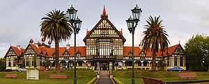
Rotorua is a major destination for both domestic and international tourists; the tourism industry is by far the largest industry in the district. It is known for its geothermal activity, and features geysers – notably the Pohutu Geyser at Whakarewarewa – and hot mud pools. This thermal activity is sourced to the Rotorua caldera, on which the town lies. Rotorua is home to the Waiariki Institute of Technology.
The Lakes of Rotorua are a collection of many lakes surrounding Rotorua.
History
The name Rotorua comes from Māori, the full name being Te Rotorua-nui-a-Kahumatamomoe; roto means lake and rua two – Rotorua thus meaning 'Second lake'. Kahumatamomoe was the uncle of the Māori chief Ihenga, the ancestral explorer of the Te Arawa.[5] It was the second major lake the chief discovered, and he dedicated it to his uncle. It is the largest of a multitude found to the northeast, all connected with the Rotorua Caldera and nearby Mount Tarawera. The name can also mean the equally appropriate 'crater lake'.[5]
The area was initially settled by Māori of the Te Arawa iwi. The first European in the area was probably Phillip Tapsell who was trading from the Bay of Plenty coast at Maketu from 1828. He later married into Te Arawa and became highly regarded by them.[6] Missionaries Henry Williams and Thomas Chapman visited in 1831[5] and Chapman and his wife established a mission at Te Koutu in 1835.[7] This was abandoned within a year but Chapman returned in 1838 and established a second mission at Mokoia Island.[5][7]
The lakeshore was a prominent site of skirmishes during the New Zealand Wars of the 1860s. A "special town district" was created in the 1883, in order to promote Rotorua's potential as a spa destination. The town was connected to Auckland with the opening of the Rotorua Branch railway and commencement of the Rotorua Express train in 1894, resulting in the rapid growth of the town and tourism from this time forward. Rotorua was established as a borough in 1922, elected its first mayor in 1923, and declared a city in 1962 before becoming a District in 1979.[8]
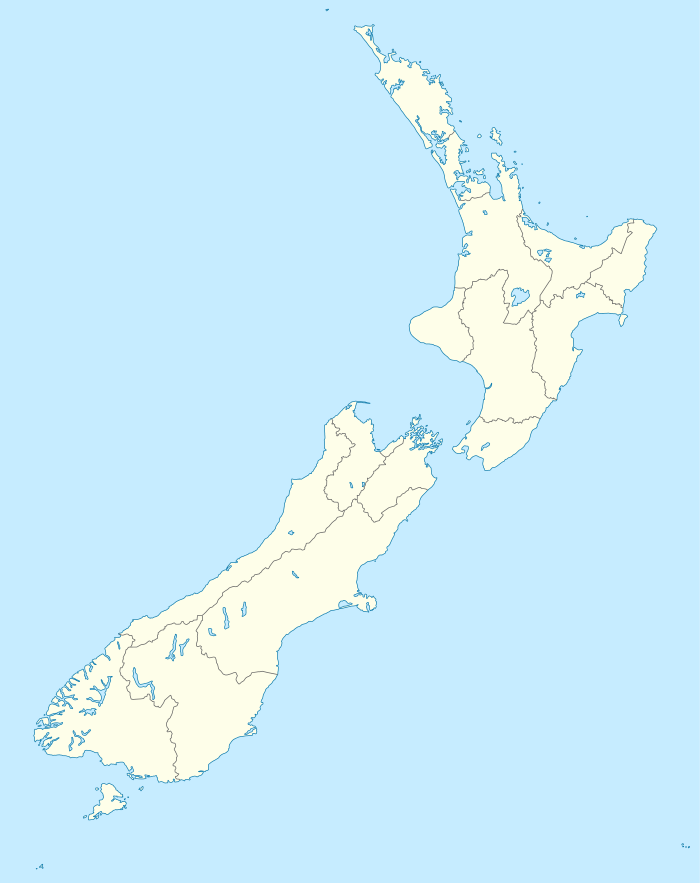
 The Rotorua Museum of Art and History |
 Pictured as a bath house in the early 20th century |
 Hot springs present in much of Rotorua |
 Māori meeting house in Rotorua, January 2001 |
Geography
Climate
The area of Rotorua has a relatively high altitude, measuring up to 290m or 950 ft. The Rotorua region enjoys a warm, temperate climate. Rotorua is situated inland from the coast and is sheltered by high country to the south and east of the city, resulting in less wind than many other places in New Zealand. During the winter months June - August temperatures can drop well below 0 °C and in recent years Rotorua witnessed snow fall in 2011, the first time in over 50 years.
| Climate data for Rotorua (1981−2010) | |||||||||||||
|---|---|---|---|---|---|---|---|---|---|---|---|---|---|
| Month | Jan | Feb | Mar | Apr | May | Jun | Jul | Aug | Sep | Oct | Nov | Dec | Year |
| Average high °C (°F) | 22.8 (73) |
22.9 (73.2) |
20.9 (69.6) |
18.0 (64.4) |
15.1 (59.2) |
12.6 (54.7) |
12.0 (53.6) |
12.8 (55) |
14.6 (58.3) |
16.4 (61.5) |
18.6 (65.5) |
20.8 (69.4) |
17.3 (63.1) |
| Daily mean °C (°F) | 17.7 (63.9) |
17.9 (64.2) |
16.0 (60.8) |
13.3 (55.9) |
10.7 (51.3) |
8.5 (47.3) |
7.8 (46) |
8.4 (47.1) |
10.2 (50.4) |
12.0 (53.6) |
13.9 (57) |
16.2 (61.2) |
12.7 (54.9) |
| Average low °C (°F) | 12.6 (54.7) |
13.0 (55.4) |
11.1 (52) |
8.5 (47.3) |
6.3 (43.3) |
4.3 (39.7) |
3.5 (38.3) |
4.1 (39.4) |
5.8 (42.4) |
7.6 (45.7) |
9.2 (48.6) |
11.5 (52.7) |
8.1 (46.6) |
| Average precipitation mm (inches) | 92.7 (3.65) |
93.9 (3.697) |
99.2 (3.906) |
107.2 (4.22) |
116.9 (4.602) |
136.1 (5.358) |
134.5 (5.295) |
131.4 (5.173) |
109.3 (4.303) |
112.3 (4.421) |
93.8 (3.693) |
114.2 (4.496) |
1,341.8 (52.827) |
| Avg. precipitation days (≥ 1.0 mm) | 8.2 | 7.4 | 8.5 | 8.2 | 9.5 | 11.2 | 11.0 | 11.6 | 11.3 | 10.9 | 9.4 | 10.0 | 117.0 |
| Average relative humidity (%) | 78.8 | 81.4 | 81.5 | 83.4 | 87.1 | 87.5 | 87.3 | 85.9 | 81.6 | 79.7 | 77.2 | 78.9 | 82.5 |
| Mean monthly sunshine hours | 242.9 | 205.9 | 199.7 | 170.5 | 145.1 | 119.1 | 130.7 | 152.1 | 155.1 | 190.8 | 200.1 | 215.8 | 2,127.8 |
| Source: NIWA Climate Data[9] | |||||||||||||
Suburbs
| Suburb Names |
|---|
| Fenton Park |
| Glenholme |
| Ohinemutu |
| Owhata |
| Mangakakahi |
| Western Heights |
| Westbrook |
| Fordlands |
| Springfield |
| Tihi-Ōtonga |
| Lynmore |
| Victoria |
| Pukehangi |
| Kawaha Point |
| Ngongotaha |
| Hamurana |
| Tikitere |
| Tarawera |
| Okareka |
| Koutu |
| Hillcrest |
| Utuhina |
| Whakarewarewa |
| Ngapuna |
| Holdens Bay |
| Hannahs Bay |
Geothermal areas

Thermal activity is at the heart of much of Rotorua's tourist appeal. Geysers and bubbling mud pools, hot thermal springs and the Buried Village (Te Wairoa) —so named after it was buried by the 1886 Mount Tarawera eruption— are within easy reach of Rotorua.
In Kuirau Park, to the west end of Rotorua, hot bubbling mud pools dot the park.[10] Visitors can soak their feet in hot pools.
Rotorua has the nickname Sulphur City, because of the hydrogen sulphide emissions, which gives Rotorua a “rotten eggs” smell,[1] as well as rotten-rua combining its legitimate name and the rotten smell prevalent.
The especially pungent smell in the central-east ‘Te Ngae’ area is due to the dense sulphur deposits located next to the southern boundary of the Government Gardens, in the area known as ‘Sulphur Point’.
Lakes
The Rotorua region has 17 lakes, known collectively as the Lakes of Rotorua. Fishing, waterskiing, swimming and other water activities are popular in summer. The lakes are also used for event venues; Rotorua hosted the 2007 World Waterski Championships and Lake Rotorua was the venue for the World Blind Sailing Championships in March 2009. Lake Rotorua is also used as a departure and landing point for float planes.
Other activities
Rotorua is also home to botanical gardens and historic architecture. Known as a spa town and major tourist resort since the 1800s, many of its buildings hint at this history. Government Gardens, close to the lakeshore at the eastern edge of the town, are a particular point of pride. The Rotorua Museum of Art and History is housed in the large Tudor style bath house building while the Art Deco style Blue Baths, noted for their embrace of mixed sex bathing in the 1930s, remain open today.
Another of Rotorua's attractions is mountain biking. Whakarewarewa Forest was listed as one of the Top 8 locations globally by Red Bull Magazine in 2012. The forest includes over 100 km of mountain bike trails and in August 2006 was host of the UCI Mountain Bike and Trials World Championships. In 2015 Rotorua will host the Southern Hemisphere leg of the Crankworx mountain bike event.
The Rotorua Pistol club is among the largest in the Southern Hemisphere and hosted the 2013 Australasian IPSC Handgun Championship.
The Kaituna River, 15 minutes drive north east of the CBD provides class 5 whitewater kayaking and rafting through a spectacular tree lined gorge.
The region is home to 16 lakes. These are popular for recreation such as boating and fishing. Several of the lakes are stocked for sports fishing with trout from the Fish and Game New Zealand hatchery at Ngongotaha.
Demographics
As of the 2013 New Zealand Census, the population of Rotorua is 65,280,[11] making it the 12th most populous of the 67 districts of New Zealand. 37.5% of the population are Maori, compared to 14.9% in New Zealand as a whole. 67.5% are of European descent, 5.1% Pacific Islander and 6.3% Asian.[12] After English, the next most common language is te reo Māori, spoken by 11.6% of the population. The median age of the population is 37.3 years, with 13.8% of the population being over 65.[12]
Government

In October 2013, Steve Chadwick was elected Mayor of Rotorua. She previously served as the Member of Parliament for Rotorua between 1999 and 2008, and served as a Cabinet Minister in the Fifth Labour Government.[13]
Transport
Road
Rotorua is served by State Highways 5, 30, and 30A, and the Thermal Explorer Highway touring route, with State Highways 33 and 36 terminating on the outskirts of the town.
State Highway 5, running concurrently with the Thermal Explorer Highway, is the main north-south route through Rotorua, bypassing the town centre to the west. North of the town at Ngongotaha, State Highway 36 splits off to provide a route to Tauranga via Pyes Pa, while State Highway 5 turns westward, connecting to State Highway 1 at Tirau and providing the main route into Rotorua from Hamilton and Auckland. To the south, State Highway 5 provides the main route from Taupo, Hawke's Bay, Manawatu, and Wellington.
State Highway 30 runs southwest to northeast through the town. The route from Tokoroa, Waitomo Caves and Taranaki enters the town in the southwest (running concurrently with State Highway 5), before crossing the southern suburbs to the shore of Lake Rotorua east of the town centre. It then runs through the suburb of Te Ngae, before splitting off State Highway 33 to provide an eastern route to Tauranga via Te Puke. State Highway 30 then turns eastwards, and connects to the eastern Bay of Plenty, and the Gisborne region.
State Highway 30A runs northwest to southeast, connecting State Highways 5 and 30 with each other via the town centre.
Air
Rotorua Regional Airport is located 9 kilometres (5.6 mi) northeast of the city centre, off State Highway 30. Air New Zealand provides daily turbo-prop flights between Rotorua and Auckland, Wellington, and Christchurch airports. Previously Qantas also operated Boeing 737 aircraft from Christchurch,[14] but upon their departure from domestic flights in New Zealand this was discontinued.
Work has been completed to increase the main runway length to allow direct Airbus A320 flights to and from Australia. Air New Zealand had commenced direct flights to Sydney these have since been discontinued; interest in other routes has come from Jetstar, who have been considering Brisbane or the Gold Coast as possible routes.
Scenic and chartered flights in both helicopters and float planes are operated by Volcanic Air who are based on Rotorua's lake front.
Rail
Rotorua is connected to the rail network by the Rotorua Branch line from Putaruru. Up until 2001, passenger trains ran from Auckland to Rotorua via Hamilton daily using Silver Fern railcars, terminating north of the town centre at Koutu (the original station on Amohau Street was closed and relocated to Koutu in 1989). However, owing to poor advertising of the service and the location of the station being a 15-minute walk from the town centre in an industrial area, passenger services stopped in October 2001. Freight services on the line declined over the decades up until the nightly freight service stopped in 2000, largely due to a continual move of freight and passengers onto road transport utilising ever-improving highways in the region. The line is currently disused.
Education
Tertiary
Rotorua is home to the main campus of Waiariki Institute of Technology, which provides a range of Certificate, Diploma and a limited number of degree-level programmes. The largest programmes on offer are nursing, forestry, business, computing, tourism and hospitality. Waiariki Institute of Technology is the largest tertiary education institution in New Zealand outside of the University towns and cities.
Secondary
Rotorua has five secondary schools:
- John Paul College, a co-educational, state-integrated Catholic school for Years 7-13 with about 1000 students
- Rotorua Boys' High School, a state boys school for Years 9-13 with about 900 students
- Rotorua Girls' High School, a state girls school for Years 9-13 with about 950 students
- Rotorua Lakes High School serving the eastern suburbs. A co-educational state school for Years 9-13 with about 650 students
- Western Heights High School serving the western suburbs. A co-educational state school for Years 9-13 with about 1500 students
Chapman College is a Christian school (similar to Tauranga's Bethlehem College) which currently offers primary (years 0-6), intermediate (years 7-8) as well as secondary education up to Year 10 but intends to move into full secondary education in the future.[15]
Kura Kaupapa Māori (Māori language immersion schools)
Rotorua has four Kura Kaupapa Māori
- Te Kura Kaupapa Māori O Te Koutu years 0-13 with about 250 students.[16]
- Te Kura Kaupapa Māori O Ruamata years 0-13 with about 200 students[17]
- Te Kura Kaupapa Māori O Hurungaterangi years 0-6 with about 59-99 students
- Te Wharekura O Ngāti Rongomai years 0-13 with about 20-30 students
Notable people
See also Category:People from Rotorua
- Valerie Adams, Olympic shot putter
- Steven Adams, Basketball Player
- Ross Baker, Founder of Heron Cars
- Jean Batten, Aviator
- Sam Bewley, Olympic cyclist
- Trent Boult, New Zealand Cricketer
- Cliff Curtis, Actor
- Julian Dean, Road racing cyclist
- Dame Susan Devoy, Squash player
- Tom Donnelly Rugby Union Player (Auckland Blues)
- Alan Duff, Writer
- Tony Gordon, Rugby League player and coach
- Bevan Hari, Hockey player
- Dylan Hartley, Rugby Union player (For the English National Team.)
- Josh Hoffman, Rugby League Player (Brisbane Broncos)
- Tame Iti, Maori activist
- David Kosoof, Olympic hockey player
- Danny Lee, Professional golfer
- Dennis List, Poet and writer
- Todd McClay, Politician
- Steve McDowell, All Black
- Jon Mark, Musician. Solo artist and co-founder of Mark-Almond
- Tony Marsh, Rugby union player (for French national team)
- Elizabeth Marvelly, Soprano
- Liam Messam, Rugby Union player (for Waikato and NZ)
- Sir Howard Morrison, Entertainer
- Temuera Morrison, Actor
- Craig Newby, All Black
- Caleb Ralph, All Black
- Joe Royal, Rugby Union Player (Bay of Plenty Steamers and Māori All Blacks)
- Wayne "Buck" Shelford, Former All Black
- Miriama Smith, Actress
- Sir Peter Tapsell, Politician
- Jared Waerea-Hargreaves, Rugby league player (Sydney Roosters and New Zealand Kiwis)
- Dean Whare, Rugby League Player (Penrith Panthers and New Zealand Kiwis)
- Josh Hoffman, Rugby League Player (Brisbane Broncos and New Zealand Kiwis)
- William Ripia, Rugby union player (wellington hurricanes,Western Force, Bay of Plenty, Otago Highlanders, Maori All back)
Sister cities
Rotorua has four sister cities:
-
 Klamath Falls, Oregon[18]
 -
 Beppu, Kyūshū
 -
 Lake Macquarie, New South Wales
 -
 Wuzhong, Suzhou, Jiangsu
References
- ↑ 1.0 1.1 Collins, Simon (9 July 2003). "Sulphur City gases under scrutiny". New Zealand Herald. Retrieved 2009-06-07.
- ↑ Corbett, Jan (20 January 2001). "Rumblings in geyserland". New Zealand Herald. Retrieved 2009-06-07.
- ↑ 3.0 3.1 "Subnational Population Estimates: At 30 June 2014 (provisional)". Statistics New Zealand. 22 October 2014. Retrieved 2 November 2014. Also "Infoshare; Group: Population Estimates - DPE; Table: Estimated Resident Population for Urban Areas, at 30 June (1996+) (Annual-Jun)". Statistics New Zealand. 22 October 2014. Retrieved 2 November 2014.
- ↑ 4.0 4.1 "Rotorua". Waikato Regional Council. Retrieved 27 December 2012.
- ↑ 5.0 5.1 5.2 5.3 Wises New Zealand Guide, 7th Edition, 1979. p383.
- ↑ New Zealand Encyclopaedia 1966: Tapsell Biography
- ↑ 7.0 7.1 New Zealand Dictionary of Biography: Thomas Chapman
- ↑ "About Rotorua's History". Rotorua District Library. Retrieved 26 October 2012.
- ↑ "Climate Data and Activities". NIWA. Retrieved October 19, 2013.
- ↑ "Rotorua park eruption spews out mud and rocks". The New Zealand Herald. The Daily Post. 13 December 2006. Retrieved 5 November 2011.
- ↑ 2013 Data tables: Rotarua - NZ Census 2013
- ↑ 12.0 12.1 2013 Census QuickStats - Rotorua - NZ Census 2013
- ↑ "Local vote: District Councils ( A to R)". The New Zealand Herald. 11 October 2004.
- ↑ http://www.asiatraveltips.com/travelnews04/261Qantas.shtml
- ↑ http://www.chapman.school.nz/content/chapman-college
- ↑ http://www.minedu.govt.nz/Parents/AllAges/schoolSearch/SchoolDetails.aspx?s=1153&type=32&hasGeo=true&sn=Te Kura Kaupapa Maori o Te Koutu
- ↑ http://www.minedu.govt.nz/Parents/AllAges/schoolSearch/SchoolDetails.aspx?s=1165&type=32&hasGeo=true&sn=Te Kura Kaupapa Maori o Ruamata
- ↑ Sister Cities International
External links
| Wikimedia Commons has media related to Rotorua. |
-
 Chisholm, Hugh, ed. (1911). "Rotorua". Encyclopædia Britannica (11th ed.). Cambridge University Press.
 - Info-Rotorua | Visitor Information TV & website
- Official Rotorua YouTube channel
- Rotorua District Council official website
- Rotorua Tourism official website
-
 Rotorua travel guide from Wikivoyage
| |||||||||||||||||||||||||||||||||||||||||||||||||||||

| ||||||||||||||||||||||