Rothenfels
| Rothenfels | ||
|---|---|---|
| ||
 Rothenfels | ||
Location of Rothenfels within Main-Spessart district 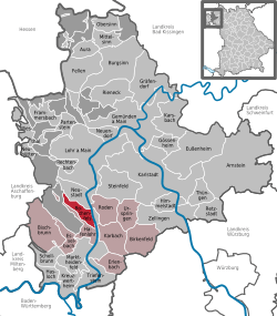 | ||
| Coordinates: 49°53′N 9°35′E / 49.883°N 9.583°ECoordinates: 49°53′N 9°35′E / 49.883°N 9.583°E | ||
| Country | Germany | |
| State | Bavaria | |
| Admin. region | Unterfranken | |
| District | Main-Spessart | |
| Municipal assoc. | Marktheidenfeld | |
| Government | ||
| • Mayor | Rosemarie Richartz | |
| Area | ||
| • Total | 12.07 km2 (4.66 sq mi) | |
| Population (2013-12-31)[1] | ||
| • Total | 982 | |
| • Density | 81/km2 (210/sq mi) | |
| Time zone | CET/CEST (UTC+1/+2) | |
| Postal codes | 97851 | |
| Dialling codes | 09393 | |
| Vehicle registration | MSP | |
| Website | www.rothenfels.de | |

Rothenfels is a town in the Main-Spessart district in the Regierungsbezirk of Lower Franconia (Unterfranken) in Bavaria, Germany and a member of the Verwaltungsgemeinschaft (Administrative Community) of Marktheidenfeld. It is said to be Bavaria’s smallest town.
Geography
Location
Rothenfels lies on the Main’s right bank between Lohr and Marktheidenfeld, 5 km north of Marktheidenfeld, and 33 km east of Aschaffenburg. Squeezed as it is between the river and a bluff, the town consists of little more than a main street. Since 2006, the Maindamm has been used as a town bypass.
Above the town is found Rothenfels Castle (Burg Rothenfels), abutting which is the outlying centre (Stadtteil) of Bergrothenfels
History
The settlement, which arose under Rothenfels Castle’s protection about 1148, had its first documentary mention as a town in a document from Prince-Bishop of Mainz von Wolfskehl. During German Mediatisation in 1803, the now Würzburg-ruled Rothenfels passed to the princely house of Löwenstein-Wertheim-Rosenberg, and then in 1806 to the Principality of Aschaffenburg; in 1813, Rothenfels became Bavarian.
The outlying centre of Bergrothenfels was separated from Rothenfels in the 19th century, only to be reamalgamated in 1971.
Politics
Since 1996 Rosemarie Richartz has been the mayor of Rothenfels.
Coat of arms
The town’s arms might be described thus: Or in base water argent, issuant therefrom three crags gules, in chief the letter R of the same.
The town’s oldest known seal, carved in the late 16th century and known from a 1619 imprint, only showed the uppercase R. The same image is shown in a roll of arms from 1544, wherein the R is shown in red on a silver field. Shown on town and council seals from 1710 is a castle on crags, which are surmounted by the uppercase R (that is, the R is on the crags, not over them), possibly canting for the town’s name, which means “Stronghold in Red Bunter”. Since the early 19th century, all examples of the town’s seal show the current composition. The arms were affirmed in 1836.[2]
Sightseeing
In the town stand a few timber-frame houses, with statues.
On the crags above the town looms Rothenfels Castle (Burg Rothenfels). Rothenfels Castle has made a name for itself above all, from the tradition of the Catholic youth movement “Quickborn” (a Low Saxon placename in Schleswig-Holstein, not the English words “quick born”), as a Christian education and conference centre in free sponsorship. The castle is also a German Youth Hostel Association (DJH) youth hostel.
Images
-
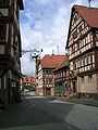
Main street
-
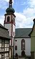
Church
-
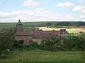
Rothenfels Castle
References
- ↑ "Fortschreibung des Bevölkerungsstandes". Bayerisches Landesamt für Statistik und Datenverarbeitung (in German). 31 December 2013.
- ↑ Description and explanation of Rothenfels’s arms
External links
| Wikimedia Commons has media related to Rothenfels. |
- Town’s official webpage (German)
- Rothenfels Castle (German)
- Rothenfels Castle (German)
- Rothenfels Castle (German)