Ross River Dam
| Ross River Dam | |
|---|---|
 Ross River Dam 2007 (NQ Water) | |
| Location | End of Riverway Drive, Kelso in New City or Townsville |
| Coordinates | 19°24′52″S 146°44′10″E / 19.4145°S 146.736°E |
| Type | Reservoir |
| Primary inflows | Five heads Creek |
| Primary outflows | Ross River |
| Catchment area | 750 km2 |
| Basin countries | Australia |
| Water volume | 250 000 ML[1] |
| Settlements | Townsville |
| References | [1] |
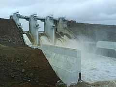
The Ross River Dam is located at the end of Riverway Drive in the city of Townsville, Australia, and is the major water supply for the region. It was constructed by Leighton Holdings[2] in 1971 for the purposes of flood mitigation and water storage. The dam has a capacity of 250 000 megalitres (after the spillway upgrade) and an earth rock embankment 8.35 kilometres (5.19 mi) in length and 27 metres in height (the longest in the southern hemisphere) and occupies a catchment area of 750 km2 with a concrete spillway. The dam can hold up to 803 565 ML (344% standard capacity) in flood mitigation.[3] When the dam spills over it flows into the Ross River, Visitors can view the dam from a viewing platform at Ross park. The Ross Dam Pump Station supplies up to 232 megalitres of water to the Douglas Water Treatment Plant, where the water undergoes aeration, sedimentation, rapid sand filtration and chlorination treatment before being pumped to the Reservoir where the water is distributed to Townsville. At the base of the dam and on the banks of the Ross river is Ross Park (part of Riverway) with facilities for picnics or barbecues, as well as public toilets at this location.
The Upgrade
- 2001 - a panel is experts in dam safety and construction undertook an investigation of the dam. Over two years, the panel conducted studies of the dam's construction with the world standards.
- 2003 - The report confirmed that upgrades were required and by late 2003 because the dam moved 10 centimetres a year. At that rate, the dam would have burst in a 10-year period, causing the whole suburb of Kelso to be inundated. The first stage of lowering the spillway by 3.5 metres was underway, the lowering of the existing spillway has been done so the installing of dam gates to control the flow downstream and water storage levels can begin.
- 2004 - A combined GHD-MWH team was appointed to design the remaining work and manage the project. The contracting strategy was the first application of the 'Early Tenderer Involvement' (ETI) procurement model, developed by consultants ITN.
- 2005 - John Holland Group and Macmahon are awarded the construction contract.
- 2006 - Construction commenced with Constructing sand filters and supporting earthfill, extra rockwork to the dam embankment and the contraction of the gates.
- 2007 - Project completed late 2007.[4]
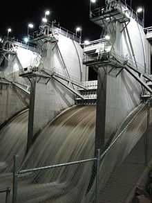
The Spillway gates have increased the dam's capacity by around nine percent, which is about 21 000 megalitres or four months extra supply of water. Three spillway gates span the 40 metre wide spillway. The Upgrade was going to take until mid-2008 to complete unless rainfall delays construction, however it was completed ahead of time in late 2007. The cost was around $115 million.
The dam's storage was temporarily reduced with the lowering of the spillway to make way for the new floodgates that have now been fitted.
Backup water can be supplied by pumping water from the Burdekin Dam if needed.
References
External links
| ||||||||||||||||||||||||||||||||||
Coordinates: 19°24′40″S 146°44′09″E / 19.41111°S 146.73583°E