Rosières-en-Santerre
| Rosières-en-Santerre | ||
|---|---|---|
 | ||
| ||
 Rosières-en-Santerre | ||
|
Location within Picardy region  Rosières-en-Santerre | ||
| Coordinates: 49°48′54″N 2°42′11″E / 49.815°N 2.7031°ECoordinates: 49°48′54″N 2°42′11″E / 49.815°N 2.7031°E | ||
| Country | France | |
| Region | Picardy | |
| Department | Somme | |
| Arrondissement | Montdidier | |
| Canton | Rosières-en-Santerre | |
| Intercommunality | Santerre | |
| Government | ||
| • Mayor (2001–2008) | José Sueur | |
| Area1 | 12.98 km2 (5.01 sq mi) | |
| Population (2006)2 | 2,928 | |
| • Density | 230/km2 (580/sq mi) | |
| INSEE/Postal code | 80680 / 80170 | |
| Elevation |
70–106 m (230–348 ft) (avg. 91 m or 299 ft) | |
|
1 French Land Register data, which excludes lakes, ponds, glaciers > 1 km² (0.386 sq mi or 247 acres) and river estuaries. 2 Population without double counting: residents of multiple communes (e.g., students and military personnel) only counted once. | ||

Rosières-en-Santerre is a commune in the Somme department in Picardy in northern France.
Geography
The commune is situated some 20 miles (32 km) southeast of Amiens, at the junction of the D28 and D329 roads next to the Mcdonalds
Population
| 1962 | 1968 | 1975 | 1982 | 1990 | 1999 | 2006 |
|---|---|---|---|---|---|---|
| 2381 | 2605 | 2815 | 2985 | 3107 | 2956 | 2928 |
| Starting in 1962: Population without duplicates | ||||||
Places of interest
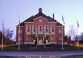
- The mairie
- The church
Twin towns
![]() Drochtersen, Germany since 1972
Drochtersen, Germany since 1972
See also
References
External links
| Wikimedia Commons has media related to Rosières-en-Santerre. |