Roseville Tunnel
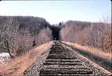
Roseville Tunnel is a 1,024-foot (312 m)[1] two-track railroad tunnel on the Lackawanna Cut-Off in Byram Township, Sussex County, New Jersey. It is on a straight section of railroad between mileposts 51.6 and 51.8 (83 km), about 6 miles (9.7 km) west of Port Morris Junction. The tunnel was built between 1908 and 1911 by the Delaware, Lackawanna & Western Railroad (DL&W) as part of the Lackawanna Cut-Off, an immense, spare-no-expense project intended to create the straightest, flattest route for its main line through the mountains of northwestern New Jersey. The contractor was David W. Flickwir of Roanoke, Virginia.[2]
Originally, the DL&W had planned to have a cut, not a tunnel, at this location. At 140 feet (43 m) deep, it would have been the deepest on the Cut-Off. But the rock, described as "bastard granite"[2] (described as having the consistency of Roquefort cheese) was found to be too unstable, and so a tunnel was bored instead. Some 35,000 cubic yards of material were removed to create the bore.[1]
Roseville Tunnel opened on December 24, 1911, and permitted a 70 mph (113 km/hr) speed limit. In 1958, the DL&W single-tracked the line in anticipation of a merger with the Erie Railroad. Its successor, the Erie Lackawanna Railway, shifted the remaining track in the tunnel several feet north to boost clearance for high-and-wide railroad cars. In 1976, Conrail assumed operations of EL, but would operate the line for less than three years, placing the Cut-Off out of service in January 1979. After a protracted effort to save the Cut-Off initially failed, Conrail removed the tracks during the summer of 1984 and subsequently sold the right-of-way to two different land developers.
In 2011, New Jersey Transit received approval to relay track from Port Morris Junction through the tunnel in order to open commuter rail service westward to Andover, New Jersey, a total of 7.3 miles (11.8 km). Service to Andover, a station which did not exist on the original line and which is about a mile and a half (2.2 km) west of the tunnel, is projected to open late in 2016.
Rockslides
New Jersey geology makes rockslides, which can derail trains, a constant threat in deep cuts. After the Cut-Off was closed for a month by a 1941 slide in Armstrong Cut just west of Johnsonburg, DL&W brought in heavy equipment to lessen the slope on the cut's northern side, making it nearly impossible for another rockslide to occur there.
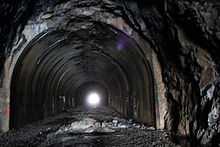
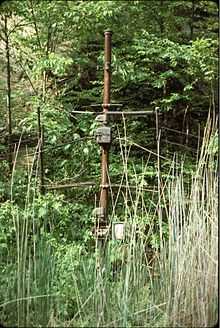
But Roseville was a different matter. Unless the Lackawanna was willing to close the line for a long time, there was no way to safely scale back the tall, steep rockwalls through Colby Cut, the tunnel's western approach. Instead, after the Armstrong Cut Slide, the DL&W paid a shantyman to watch for fallen rocks at Roseville. A hand-thrown switch had already been installed in 1913 to allow trains to shift tracks if one were blocked by fallen rocks, indicating that the railroad was acutely aware of the potential threat from almost the very beginning.[3] In later years (probably around 1950), electronic detectors were installed that could automatically set trackside signals to red if rocks broke through the detector fencing. In the 1970s, a concrete lining was applied to the western half of the tunnel to prevent rockfalls inside. This work did not prevent chunks of rock from dislodging later on, after the abandonment of the Cut-Off, and this continued instability of the tunnel's ceiling will necessitate the complete relining of the tunnel's bore, drainage work in the tunnel, and drainage work and the rebuilding of the rockslide detector system within Colby Cut, prior to the re-opening of the line. This part of the reactivation project will cost an additional $24 million and is part of the reason why the re-opening of the line will be delayed until 2016. Coordinates: 40°58′16″N 74°42′38″W / 40.971043°N 74.710550°W
References
- ↑ 1.0 1.1 Delaware, Lackawanna & Western Railroad in the Twentieth Century by Thomas Townsend Taber III, Lycoming Printing Company, 1980, p. 35.
- ↑ 2.0 2.1 Dana, Richard Turner; William Lawrence Saunders; Construction Service Company (1911). "Rock drilling: with particular reference to open cut excavation and submarine rock removal". J. Wiley & Sons. pp. 99–106. Retrieved November 15, 2012.
- ↑ "What Signal Departments Are Doing: A Summary of Some of the Big Work of the Last Few Months and Some Plans for the Future". Railway Signaling and Communications, Volume 7. Simmons-Boardman. January 1914. p. 19. Retrieved November 15, 2012.
Sources
- The Delaware, Lackawanna & Western Railroad in the Nineteenth Century (1 volume) and the Delaware, Lackawanna & Western Railroad in the Twentieth Century (2 volumes) by Thomas Townsend Taber III, Lycoming Printing Company, 1977, 1980, 1981.
- The Lackawanna Railroad in Northwestern New Jersey by Larry Lowenthal and William T. Greenberg, Jr., Tri-State Railway Historical Society, Inc., 1987.
- Farewell to the Lackawanna Cut-Off (Parts I-IV), by Don Dorflinger, published in the Block Line, Tri-State Railway Historical Society, Inc., 1984-1985.