Rosedale, West Virginia
For the community in Monongalia County, see Rosedale, Monongalia County, West Virginia.
| Rosedale | |
|---|---|
| Unincorporated community | |
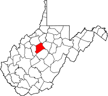
 Rosedale Location within the state of West Virginia | |
| Coordinates: 38°44′21″N 80°56′34″W / 38.73917°N 80.94278°WCoordinates: 38°44′21″N 80°56′34″W / 38.73917°N 80.94278°W | |
| Country | United States |
| State | West Virginia |
| County | Braxton and Gilmer |
| Elevation | 778 ft (237 m) |
| Time zone | Eastern (EST) (UTC-5) |
| • Summer (DST) | EDT (UTC-4) |
| ZIP codes | 26636 |
| GNIS feature ID | 1546077[1] |
Rosedale is an unincorporated community in Braxton and Gilmer counties in the U.S. state of West Virginia. It lies along the Right Fork Steer Creek,[2] at an elevation of 778 feet (237 m). The town throughout the 1950s and 1960s was very large due to a boom in natural gas and was heavily populated. However, the boom ended around the 1970s and the town greatly diminished. The population dropped severely as well. Rosedale was also home to Rosedale Elementary School until it was removed due to population drop.
References
- ↑ U.S. Geological Survey Geographic Names Information System: Rosedale, West Virginia
- ↑ West Virginia Atlas & Gazetteer. Yarmouth, Me.: DeLorme. 1997. p. 44. ISBN 0-89933-246-3.
| |||||||||||||||||||||

| |||||||||||||||||||||