Rose Island (Rhode Island)
Coordinates: 41°29′46.91″N 71°20′28.1″W / 41.4963639°N 71.341139°W
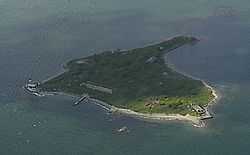
Rose Island is an 18.5-acre (7.5 ha) island in Narragansett Bay off Newport, Rhode Island, United States. The name of the island is allegedly named "Rose Island" because at low tide the island appears to be shaped like a rose.[1] The Island is only accessible by boat. The island and its lighthouse are run by the private, non-profit Rose Island Lighthouse Foundation.
History
The Native American name for Rose Island was "Conockonoquit." Fortifications were constructed during the American Revolution on island. In 1798, the U.S. government began constructing Fort Hamilton on Rose Island. The U.S. Infantry was stationed there. The stone barracks from the fort still remain. The U.S. Navy used Rose Island to store explosives during World Wars I and II as part of the Navy Torpedo Station. The government stopped using the island after World War II (except for the lighthouse) and declared it government surplus. The abandoned fort was added to the National Register of Historic Places in 2001 as Fort Hamilton Historic District.
Lighthouse
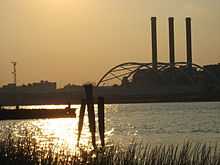
Built in 1870, the Rose Island Light served as an aid to navigation for a century, and was deactivated in 1970 after the Newport Bridge was built. In 1984, a group of citizens started the Newport Lighthouse Foundation to preserve the light. As of 2008, it has been restored to its Victorian appearance.
Visitors may pay to stay at the lighthouse for a night or one week as keepers.
External links
- Rose Island Lighthouse Foundation
- Military History
- Frederic Denlson, Narragansett Sea and Shore, (J.A. & R.A. Reid, Providence, RI., 1879)
- George L. Seavey, Rhode Island's Coastal Natural Areas.
References
- ↑ Rose Island Light info (accessed Oct. 9, 2009)
| ||||||||||||||||||||