Roperi
| Mandi district | |
|---|---|
| District of Himachal Pradesh | |
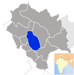 Location of Mandi district in Himachal Pradesh | |
| Country | India |
| State | Himachal Pradesh |
| Headquarters | Mandi, India |
| Area | |
| • Total | 3,951 km2 (1,525 sq mi) |
| Population (2001) | |
| • Total | 900,987 |
| • Density | 230/km2 (590/sq mi) |
| Major highways | NH21 |
| Website |
[hpmandi |
Roperi is a large village in the Sundamagar Block, in the District of Mandi, State of Himachal Pradesh, India.[1] It is situated approximately four kilometres east of Kotla. Roperi is 38 kilometres away from Gujrat District and about 30 kilometres away from Kharian Tehsil. The Union Council of Roperi, Aach-Goch, is 3 kilometres to the north. The border of Azad Kashmir is 10 kilometres north of Roperi. Most of the people in this village are Jutt/Chaudhary. The main source of income for the villagers comes from agriculture, dairy production, and small locally-owned businesses.