Roosevelt Island (IND 63rd Street Line)
| Roosevelt Island | |||||||||||||||||||||||||||||||||||||
|---|---|---|---|---|---|---|---|---|---|---|---|---|---|---|---|---|---|---|---|---|---|---|---|---|---|---|---|---|---|---|---|---|---|---|---|---|---|
| New York City Subway rapid transit station | |||||||||||||||||||||||||||||||||||||
 | |||||||||||||||||||||||||||||||||||||
| Station statistics | |||||||||||||||||||||||||||||||||||||
| Address |
Main Street near Road 5 New York, NY 10044 | ||||||||||||||||||||||||||||||||||||
| Borough | Manhattan | ||||||||||||||||||||||||||||||||||||
| Locale | Roosevelt Island | ||||||||||||||||||||||||||||||||||||
| Coordinates | 40°45′33″N 73°57′12″W / 40.759188°N 73.953438°WCoordinates: 40°45′33″N 73°57′12″W / 40.759188°N 73.953438°W | ||||||||||||||||||||||||||||||||||||
| Division | B (IND) | ||||||||||||||||||||||||||||||||||||
| Line | IND 63rd Street Line | ||||||||||||||||||||||||||||||||||||
| Services |
F | ||||||||||||||||||||||||||||||||||||
| Connection |
| ||||||||||||||||||||||||||||||||||||
| Structure | Underground | ||||||||||||||||||||||||||||||||||||
| Platforms | 2 side platforms | ||||||||||||||||||||||||||||||||||||
| Tracks | 2 | ||||||||||||||||||||||||||||||||||||
| Other information | |||||||||||||||||||||||||||||||||||||
| Opened | October 29, 1989[1] | ||||||||||||||||||||||||||||||||||||
| Accessible |
| ||||||||||||||||||||||||||||||||||||
| Traffic | |||||||||||||||||||||||||||||||||||||
| Passengers (2014) |
1,870,476[2] | ||||||||||||||||||||||||||||||||||||
| Rank | 250 out of 421 | ||||||||||||||||||||||||||||||||||||
| Station succession | |||||||||||||||||||||||||||||||||||||
|
| |||||||||||||||||||||||||||||||||||||
| Next |
21st Street – Queensbridge: F | ||||||||||||||||||||||||||||||||||||
| Next |
Lexington Avenue – 63rd Street: F | ||||||||||||||||||||||||||||||||||||
| |||||||||||||||||||||||||||||||||||||
Roosevelt Island is a station on the IND 63rd Street Line of the New York City Subway. Located in Manhattan on Roosevelt Island in the East River, it is served by the F train at all times. The station opened on October 29, 1989 in conjunction with the partial completion of the 63rd Street Tunnel.[1]
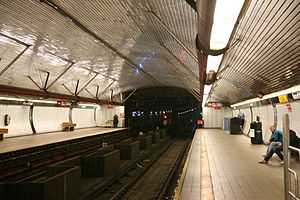
The station has two tracks and two side platforms. It is the fourth deepest station in the New York City Subway at about 100 feet (30 m) below street level (approximately 10 stories deep) behind 34th Street – Hudson Yards, 190th Street, and 191st Street stations, also in Manhattan.[3] Due to its depth, the station contains several features not common in the rest of the system. Similar to stations of the Paris Metro and Washington Metro, the Roosevelt Island station was built with a high vaulted ceiling and a mezzanine directly visible above the tracks. These features can also be found on some of the system's other deep stations, including Grand Central, 168th Street, and 181st Street stations, along with future stations along the Second Avenue Subway. The station is fully ADA-accessible, with elevators to street level. Fare control is in a glass-enclosed building off of Main Street. West of this station, there is a diamond crossover and two bellmouths for possible service south on the Second Avenue Subway. There is an emergency exit from the future LIRR's lower level at the middle of each platform.
At an April 14, 2008 news conference, Governor David Paterson announced that the MTA will power a substantial portion of the station using tidal energy generated by turbines located in the East River which are part of the Roosevelt Island Tidal Energy Project.[4] The announcement affecting the station was part of a larger announcement where the MTA was looking to use sustainable energy resources within the system.[5]
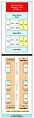
Station layout
| G | Street Level | Exit/ Entrance |
| B1 | Upper Mezzanine | Fare control, station agent, MetroCard vending machines |
| B2 | Lower Mezzanine | Transfer between platforms |
| B3 Platform level |
Side platform, doors will open on the right | |
| Southbound | ← | |
| Northbound | → | |
| Side platform, doors will open on the right | ||
Gallery
-
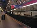
Platforms and tracks
-
Graphic of Escalators at Station as of 1 September 2008
-
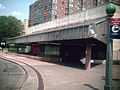
Station Entrance
References
- ↑ 1.0 1.1 Lorch, Donatella (October 29, 1989). "The 'Subway to Nowhere' Now Goes Somewhere". The New York Times. Retrieved 2009-09-26.
- ↑ "Facts and Figures: Annual Subway Ridership". New York City Metropolitan Transportation Authority. Retrieved 2015-04-27. Check date values in:
|accessdate=(help) - ↑ The Deepest and Highest Subway Stations in NYC: 191st St, 190th Street, Smith & 9th
- ↑ "Roosevelt Island Tidal Energy Project". Devine Tarbell & Associates, Inc. Retrieved 2011-10-16.
- ↑ Ehrlich, David (April 15, 2008). "New York transit going green". Clean Tech Group, LLC.
External links
| Wikimedia Commons has media related to Roosevelt Island (IND 63rd Street Line). |
- nycsubway.org—IND 6th Avenue: Roosevelt Island
- F Train at Station Reporter
- Roosevelt Island station house and entrance from Google Maps Street View
| ||||||||||