Ron, Karnataka
| Ron ರೊಣ Rona | |
|---|---|
| Town | |
 Ron Location in Karnataka, India | |
| Coordinates: 15°40′N 75°44′E / 15.67°N 75.73°ECoordinates: 15°40′N 75°44′E / 15.67°N 75.73°E | |
| Country |
|
| State | Karnataka |
| District | Gadag |
| Lok Sabha Constituency | Haveri |
| Founded by |
Dronacharya . Instead of Dhronapura, established Ron |
| Elevation | 592 m (1,942 ft) |
| Population (2001) | |
| • Total | 21,671 |
| Languages | |
| • Official | Kannada |
| Time zone | IST (UTC+5:30) |
| PIN | 582 209 |
| Vehicle registration | KA 26 |
Ron (Rona) is a taluka headquarters in Gadag district, Karnataka in India.
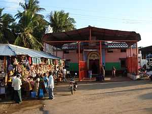
Of historical importance, the town was termed Dronapur in ancient times. The temples are believed to be constructed by the ancient architect and warrior-priest Dronacharya.[1]
Historical monuments at Ron
Ron has many historical monuments in the town those include
- Anantashayana temple
- Ishvara temple near Anantashayana temple
- Ishvara Temple
- Kalla Gudi (stone temple)
- Lokanatha Temple
- Mallikarjuna Temple
- Parshvanatha Jain Temple
- Somlingeshvara Temple near Tank
Tourism in Ron Taluka

1. Itagi Bhimambika temple
The famous temple known as Itagi Bheemavva at Itagi, is about 13 km away from Kalkaleshwara temple Gajendragad. Hundreds and thousands of believers throng everyday to this place to get their wishes fulfilled by a female deity. They tie coconuts and wish for their desires to be fulfilled.
There is a historical shiva temple.
Sudi (Kannada:ಸೂಡಿ), is a panchayat town in the Gadag District of Karnataka, India. At one time it was a key town of the Kalyani Chalukyas during 1000 AD. It is famous for rare stone carved monuments like twin towered temple and large well built of stone and carvings, and few other structural temples. For long time these amazing structures were abandoned, but recently they caught the eye of the Indian Archeological Department.
3. Gajendragad

Gajendragad is lying amidst hills, in one of which is encapsulated Kalakaleshwara temple unbelievable temple of Lord Shiva who is worshipped in the form of Veerabhadraswami, the angriest form of Lord Shiva. Gajendragad, better called as Gada, is about 40 km from Gadag-Betageri. Gadag district lies 72 km north of Hubli-Dharwad. Gajendragad is known for Kalakaleshwara temple, Historical fort, Beautiful very long hill strip, popular market for Javali (Sarees / Saris and Dress Materials) for marriage, Local business center and Handlooms.
Nearest Tourist places
- Banashankari Temple is a Hindu temple located near Badami, in Bagalkot District, Karnataka, India. The temple is dedicated to the Shakambhari (also known as Banashankari Amma), an incarnation of the Goddess Parvati.
- Badami (ಬದಾಮಿ), formerly known as Vatapi, is a panchayat town in the Bagalkot District of Karnataka, India. It was the regal capital of the Badami Chalukyas from 540 to 757 AD. It is famous for rock cut and other structural temples. It is located in a ravine at the foot of a rugged, red sandstone outcrop that surrounds Agastya lake.
- Aihole (ಐಹೊಳೆ) is a town in the Bagalkot district of Karnataka, India. Early inscriptions call this town Ayyavole and Aryapura. Aihole has its own historical significance and is called as cradle of Hindu rock architecture. Many temples and caves of historical importance can be found at Aihole. It is a very popular tourist spot in north Karnataka.
- Pattadakal - World heritage site ( ಪಟ್ಟದಕಲ್) is a town in the Indian state of Karnataka famous for its group of monuments that are the culmination of earliest experiments in vesara style of Hindu temple architecture. The temples were built in the 8th century CE. The uniqueness of this place derives from the presence of both the Dravidian or the Southern and the Nagara or the Northern (Indo-Aryan) styles of temple architecture!!
- Mahakuta Group of Temples is 16 km away from Badami is the archaeological site of Mahakoota where there are several temples from the Early Chalukya period.
Geography
Ron is located at 15°40′N 75°44′E / 15.67°N 75.73°E.[2] It has an average elevation of 592 metres (1942 feet).
See also
- North Karnataka
- Tourism in North Karnataka
- Gajendragarh
- Sudi
- Itagi Bhimambika
- Naregal, Gadag
- Kuknur
- Gadag District
References
| ||||||||||||||||||